Tier 1 EIS
Tier 1 Draft EIS
2. Readers' Guide
View as PDF
Table of Contents
2. Readers' Guide
As described in Chapter 1, Introduction, the Federal Railroad Administration (FRA) determined that it was appropriate to use a tiered National Environmental Policy Act (NEPA) process for completing the environmental review for NEC FUTURE. Moreover, the size and complexity of NEC FUTURE required that the FRA develop specific effects-assessment methodologies and a set of tools for analyzing environmental impacts across the multijurisdictional NEC FUTURE Study Area (Study Area). The Readers' Guide presents the overall organization of this Tier 1 Draft Environmental Impact Statement (Tier 1 Draft EIS) and defines key concepts, methodologies, and terminologies used in the environmental analyses.
2.1 Organization of this Tier 1 Draft EIS
This Tier 1 Draft EIS comprises a main body and multiple appendices, the latter providing supporting documentation. The main body -in addition to providing information on existing conditions and descriptions of the No Action and Action Alternatives analyzed in this Tier 1 Draft EIS -summarizes the findings of the analyses conducted to assess the effects of the Action Alternatives. The appendices provide additional information on the development of the Action Alternatives and technical analyses of environmental and other resources, including a mapping atlas; the effects-assessment methodologies; environmental impact data, agency coordination and public outreach information; Section 106 documentation; and the Section 4(f)/6(f) evaluation.
2.1.1 Main Body
The main body of this Tier 1 Draft EIS provides a detailed statement of the Purpose and Need (Chapter 3) for NEC FUTURE and descriptions of the Alternatives Considered (Chapter 4) in this Tier 1 Draft EIS. Subsequent chapters focus on the analysis of the No Action and Action Alternatives for various topics:
- Transportation Effects (Chapter 5) analyzes regional and local effects of the No Action and Action Alternatives on the multimodal transportation network, including changes in mode of travel, volume of travel, and services offered.
- Economic Effects and Growth, and Indirect Effects (Chapter 6) analyzes direct and indirect economic and induced growth effects of the No Action and Action Alternatives, including employment, construction activity, monetized total values for transportation effects, and long-term market effects.
- Affected Environment, Environmental Consequences, and Mitigation (Chapter 7) analyzes existing conditions and potential effects of the No Action and Action Alternatives on the built and natural environments.
- Construction Effects (Chapter 8) presents an overview of the potential construction activities associated with each of the Action Alternatives and related short-term effects associated with those activities.
- Evaluation of Alternatives (Chapter 9) compares the No Action and Action Alternatives based on a range of metrics to evaluate how well the No Action and Action Alternatives perform relative to service, operations, ridership, economic benefits, environmental effects, and other evaluation criteria.
- Phasing and Implementation of Alternatives (Chapter 10) describes preliminary phasing plans and associated costs and benefits, as well as implementation opportunities and challenges, for each Action Alternative.
- Agency and Public Involvement (Chapter 11) summarizes agency and public involvement activities undertaken as part of the development of this Tier 1 Draft EIS.
- References (Chapter 12) lists sources and references for the analysis and documentation presented.
- Glossary (Chapter 13) explains terminology and acronyms used throughout this Tier 1 Draft EIS.
- List of Preparers (Chapter 14) identifies persons involved in the analysis and development of this Tier 1 Draft EIS.
- Index (Chapter 15) guides the reader in finding specific items within this Tier 1 Draft EIS.
2.1.2 Appendices
The following appendices provide the detailed technical documentation, calculations, and relevant coordination materials that support the findings presented in the main body:
- Appendix A, Mapping Atlas, supports the understanding of the geography of the Action Alternatives and the document resources. This atlas presents maps from south to north and allows the reader to follow each Action Alternative from Washington, D.C., through New York City and into Boston in relation to mapped resources. The atlas highlights areas where new infrastructure is proposed for each of the Action Alternatives and coincides with the discussed mapped resources (Part 1). It also provides a separate map series that focuses in on the Representative Route for each Action Alternative (Part 2).
- Appendix B, Alternatives Documentation, provides technical reports and memoranda that support the development of the Action Alternatives presented in Chapter 4.
- Appendix C, Transportation, provides the effects-assessment methodology and technical data that support the transportation analysis presented in Chapter 5.
- Appendix D, Economic Effects and Growth, and Indirect Effects, provides the effects-assessment methodology and technical data that support the economic effects and indirect effects analysis presented in Chapter 6.
- Appendix E, Environmental Resource Documentation, provides detailed documentation that supports Chapter 7. Each resource presented in Chapter 7 has its own corresponding section within Appendix E; each of these sections is organized geographically and by alternative to provide more detailed information at the state and county level. Each section includes a resource-specific effects-assessment methodology and a description of the application of the resource-specific effects-assessment methodology that explains the approach to summarizing information that is presented in the main body of the Tier 1 Draft EIS, and environmental impact data.
- Appendix F, Agency and Public Involvement, provides supporting documentation for the agency and public involvement described in Chapter 11. Specifically, the appendix includes the public involvement plan, agency coordination plan, public Notice of Intent, information related to the Tier 1 EIS Scoping process, and various stakeholder engagements, briefings, and meetings.
- Appendix G, Section 106 Documentation, provides documentation relevant to compliance with Section 106 of the National Historic Preservation Act. Relevant documentation includes a record of the coordination with State Historic Preservation Offices, the Advisory Council on Historic Preservation, and Government-to-Government Tribal coordination. It also provides the draft Programmatic Agreement for public review and comment.
- Appendix H, Preliminary Section 4(f) and Section 6(f) Evaluations, documents the preliminary assessment and evaluation of Section 4(f) of the U.S. Department of Transportation Act and Section 6(f) of the Land and Water Conservation Fund Act (LWCF Act) resources that were identified within the Affected Environment that could be affected by the Action Alternatives.
2.2 Key Concepts
The proposed action in this Tier 1 EIS is the adoption of an investment program to improve passenger rail service within the Study Area. This Tier 1 Draft EIS documents existing conditions and Environmental Consequences of a No Action Alternative and a range of Action Alternatives for the proposed action. Effects analyses of the Action Alternatives are based on assumption of full build-out of alternatives, and future population and ridership projections for the year 2040 (see also Section 2.2.2). This Tier 1 Draft EIS describes Environmental Consequences at a programmatic level that is consistent with the level of detail and broad geographic extent of the Action Alternatives. It is important to recognize that the NEC FUTURE analysis is not intended to provide the basis for selection of an exact alignment; therefore, the analysis does not contain the level of engineering or environmental detail needed to make a specific alignment decision. That information would be developed in Tier 2 NEPA studies.
2.2.1 Environmental Level of Detail and Analysis
The FRA, as the lead federal agency, has determined that a tiered environmental review process is appropriate for the following reasons:
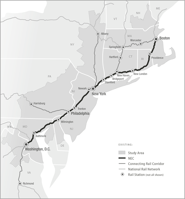
- The Study Area (Figure 2-1) includes a broad geographic area, stretching 457 miles from Washington, D.C., in the south to Boston, MA, in the north, and covering over 50,000 square miles. The analysis of markets and services connecting to the Northeast Corridor (NEC) considers areas outside of the Study Area, such as Virginia and New Hampshire.1
- The decision at this stage involves the selection of a preferred investment program to improve passenger rail service for the NEC. Tier 2 projects would be defined and project-level approvals would be made, in most cases, following the selection of a preferred investment program.
- At this stage, the FRA is conducting conceptual planning and design, at a level of detail needed to support programmatic decisions. More detailed design and environmental analysis would be conducted when project-level decisions are made.
Figure 2-1 : Study Area Map
Source: NEC FUTURE team, 2015
The size of the Study Area presents special challenges in deciding how to document existing conditions and assess Environmental Consequences in a way that is meaningful to the reader and to the decisions to be made. For example, existing conditions would typically be described for an entire study area. However, the geographic coverage of this Study Area requires an approach that defines existing conditions sufficiently to assess Environmental Consequences without creating a voluminous encyclopedia of data. Therefore, the FRA describes existing conditions and Environmental Consequences for geographic areas within the Study Area. Consistent with the level of detail used to define geographic areas, each Action Alternative is defined with a Representative Route rather than an exact alignment. The FRA developed a Representative Route for each Action Alternative in order to assess a range of possible environmental effects (see Section 2.2.3). The effects assessment presented is not intended to fully inform the selection of a specific alignment, but rather to represent possible effects.
2.2.2 Horizon Year
As part of a NEPA analysis, a "horizon year" is considered when conducting analysis. The horizon year refers to the future timeframe within which Environmental Consequences associated with the construction and operation of the No Action and Action Alternatives will be assessed. The horizon year is considered to be the year through which future population and employment growth as well as travel demand can be reasonably forecasted for the No Action and Action Alternatives, though, as with any forecasts, such projections of future population and employment have some degree of uncertainty. This Tier 1 Draft EIS uses 2040 as the horizon year.
2.2.3 Existing NEC, Representative Routes, Affected Environment, and Context Area
To ensure consistency in the level of detail for both defining alternatives and assessing environmental effects, the FRA developed an approach to define the physical routing of each Action Alternative and to establish the boundaries for assessing environmental effects. The following terminology describes the approach and is used throughout this Tier 1 Draft EIS:
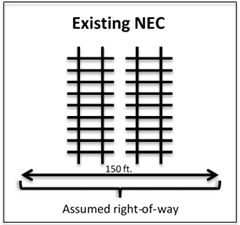
- Existing NEC refers to the assumed right-of-way of the NEC and is the footprint used in this Tier 1 Draft EIS to characterize environmental conditions of the existing NEC. The FRA standardized the width of the existing NEC to 150 feet, conservatively accounting for a four-track right-of-way between Washington, D.C., and Boston. The 150-foot width is inclusive of tracks, ballast, signals, etc.
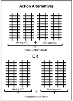
- Representative Route is the route associated with an Action Alternative. The Representative Route includes the physical footprint of the improvements associated with the Action Alternatives. The dimensions of the footprint of the Representative Route are based on cross sections identifying construction type (e.g., tunnel, viaduct, bridge, embankment, at-grade) that are applied to topography or land use type, stations, supporting facilities, and right-of-way requirements. The footprints associated with the Representative Routes range from 150 feet to 300 feet wide. Improvements associated with stations and supporting facilities (i.e., tracks, platforms, parking) could flare out beyond the dimensions of the Representative Route.2
The width of the Representative Route for an Action Alternative includes the existing NEC and any new segment(s), where applicable. In some instances, a Representative Route consists of the existing NEC and new segment being adjacent and parallel to each other. In other instances, a Representative Route consists of the existing NEC and new segment being separated. An example would be a new segment proposed to create a bypass or an alternate route option to access a new geographic market. (See Section 4.2.4 for additional information.)
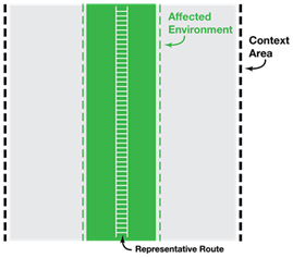
- Affected Environment is the geographic area for which the FRA identified existing conditions and Environmental Consequences for the existing NEC and Action Alternatives. The width of the Affected Environment varies based on the resource, but at a minimum is 2,000 feet wide, centered on the Representative Route. In some cases where appropriate to accurately characterize the resource, the Affected Environment encompasses the entire Study Area.
- Context Area is a broader geographic area that extends beyond the Affected Environment. The FRA defines a standardized Context Area of uniform width as 5 miles wide, centered on the Representative Route, for all resources. For those resources for which the Affected Environment encompasses the entire Study Area, there is no Context Area analysis. The Context Area allows for qualitative evaluation of potential shifts in Representative Routes.
Figure 2-2 shows the relationship among the Representative Route, Affected Environment, and Context Area. These areas are all within the broader Study Area.
Figure 2-2 : Illustration of Representative Route, Affected Environment, and Context Area
2.2.4 Data Sources and Geographic Information System Tools
The FRA analyzed readily available secondary source data (e.g., geographic information system [GIS]-based, published reports, technical analyses), and did not conduct fieldwork or subsurface testing of any kind as part of this Tier 1 Draft EIS.
The FRA created a GIS database for NEC FUTURE to compile, store, and analyze data to use in documenting existing conditions and the assessment of Environmental Consequences.3 The data were reviewed carefully to ensure a uniform level of detail since the data were collected from a variety of sources. The FRA incorporated future-year projections and calculations relative to population and employment, travel demand, and related topics that were developed for NEC FUTURE into the GIS database for use in resource-specific analyses. This GIS database also included information that was developed to define the characteristics of each Action Alternative, such as routes, stations, service types, and frequency. Together, resource-specific data (e.g., land cover, demographics, and ecological resources) and information about the Action Alternatives are layers in the GIS database. The interaction of these layers defined the Affected Environment and was used to assess Environmental Consequences.
2.2.5 Alternatives Development and Terminology
As appropriate, the FRA defines specific terms relevant to the No Action and Action Alternatives in the relevant chapter or section. The following terms are fundamental to the initial description of the Study Area and its available passenger services:
- NEC (also referred to as the NEC Spine) is the existing rail transportation spine of the Northeast region -anchored by Washington Union Station in the south, Penn Station New York in the center, and Boston South Station in the north. The NEC connecting corridors refer to those rail corridors that connect directly to a station on the NEC. These include (1) corridor service south of Washington Union Station to markets in Virginia (i.e., Lynchburg, Richmond, Newport News, Norfolk) and North Carolina (i.e., Charlotte); (2) Keystone (connects Philadelphia 30th Street Station to Harrisburg Station); (3) Empire (connects Penn Station New York to Niagara Falls Station); and (4) New Haven-Hartford-Springfield (connects New Haven Union Station to Springfield Union Station) (Chapter 13: Glossary).
- Regional refers to traditional peak or off-peak commuter or regional travel, generally defined by trips that start or end within the same metropolitan area. Regional trips are typically served by commuter or regional railroads within a metropolitan area or within a state. Throughout the Tier 1 Draft EIS, commuter or regional railroads are referred to as Regional rail.
- Interregional refers to travel between metropolitan areas that start or end in different metropolitan areas. Interregional trips are generally served by Intercity railroads (Amtrak), offering services that connect cities or metropolitan areas at speeds and distances greater than that of commuter rail.
- No Action Alternative defines conditions that will exist in the 2040 analysis year if the proposed action is not implemented. (Under NEPA, the No Action Alternative is sometimes referred to as the No Build condition.) For NEC FUTURE, the No Action Alternative is a baseline against which the FRA compares the effects of each of the Action Alternatives. The No Action Alternative represents the condition of the Northeast region's multimodal transportation system in 2040.
- Action Alternatives refer to the action or build alternatives considered in this Tier 1 Draft EIS. For NEC FUTURE, three Action Alternatives are being advanced:
- Alternative 1 maintains the role of rail as it is today in the region, with the level of rail service keeping pace with the growth in population in the Study Area.
- Alternative 2 grows the role of rail, expanding rail service at a rate greater than the proportional growth in regional population and employment.
- Alternative 3 transforms the role of rail, supporting trips over longer distances and to places not currently well connected by passenger rail, positioning rail as the dominant mode for Interregional travel to urban centers along the NEC.
All Action Alternatives include the following:
- Improvements to the existing NEC; the existing NEC is never abandoned.
- Representative Service plans developed in coordination with stakeholders for the purposes of analysis.
- Representative Routes connecting geographic markets.
The No Action and Action Alternatives all share common termini -they all start at Washington Union Station in Washington, D.C., and end at South Station in Boston. All Action Alternatives include the existing NEC; none abandon any portion of the existing NEC. All Action Alternatives represent an end-to-end service plan between Washington, D.C., and Boston and present an end-to-end Representative Route. However, Alternative 3 provides route options between New York City and Hartford, CT, and between Hartford and Boston. The following terms are used to provide geographic routing context for Alternative 3:
- Washington, D.C., to New York City refers to the southern portion of Alternative 3 between Washington Union Station in Washington, D.C., and the New Jersey/New York state line at the Hudson River.
- New York City to Boston refers to the northern portion of Alternative 3 between the New Jersey/New York state line to South Station in Boston. There are several route options between New York City and Boston:
- New York City to Hartford via Central Connecticut refers to the route option that extends from New York City to Hartford, CT, by way of Danbury, CT.
- New York City to Hartford via Long Island Sound refers to the route option that extends from New York City to Hartford by way of Ronkonkoma, across the Long Island Sound, and through New Haven, CT.
- Hartford to Boston via Providence refers to the route option that extends from Hartford through Tolland and Windham Counties, CT, to Providence, RI, and continuing to South Station in Boston.
- Hartford to Boston via Worcester refers to the route option that extends from Hartford through Worcester, MA, continuing to South Station in Boston.
In some sections of this Tier 1 Draft EIS, Alternative 3 is represented as Central CT/Providence (Alternative 3.1), Long Island/Providence (Alternative 3.2), Long Island/Worcester (Alternative 3.3), and Central CT/Worcester (Alternative 3.4). These are considered the representative end-to-end route options for service-related analysis specific to Alternative 3.
The characteristics of the No Action and Action Alternatives, including the geographic location and key environmental features of the Representative Route are presented in Chapter 4, Alternatives Considered.
Footnotes
1 The NEC refers to the spine or main line of the railroad anchored by Washington Union Station in the south, Penn Station New York in the center, and Boston South Station in the north.
2 The FRA did not evaluate other ancillary facilities, such as maintenance and storage yards, traction power substations, etc. in this Tier 1 Draft EIS. The FRA did not identify specific locations of these facilities as part of the development of alternatives (see Chapter 4, Alternatives Considered).
3 See Appendix A, Mapping Atlas, and Appendix E, Environmental Resource Documentation, for GIS sources.