This Readers' Guide presents guidance on how to "use" this
document, defines key concepts and terminology used in the environmental
analyses, and provides the overall organization of this Tier 1 Final
Environmental Impact Statement (Tier 1 Final EIS).
This Tier 1 Final EIS is presented as two volumes. Volume 1 focuses
on the description and analysis of the Preferred Alternative. It also
includes a summary of comments received during the public comment period
for the Tier 1 Draft EIS and responses to those comments (Chapter 11,
Agency and Public Involvement and Appendix JJ). In addition, Volume
1 includes its own set of appendices that support the evaluation of
the Preferred Alternative and provides all comments received during
the public comment period.
Volume 2 contains the entire Tier 1 Draft EIS, including appendices,
updated to reflect changes noted during the public comment period (November
2015 to February 2016). Updates include clarifications, errata-style
edits, and specific comments related to information provided in the
Tier 1 Draft EIS. The Federal Railroad Administration (FRA) determined
that it would be beneficial to provide the revised Tier 1 Draft EIS
as part of this Tier 1 Final EIS because the Tier 1 Draft EIS provides
valuable information for elements that were included as part of the
Action Alternatives, but that were not included in the Preferred Alternative.
Such elements may be re-considered in the future under separate planning
processes and evaluations.
2.1 How to "Use" Volume 1 and Volume 2
Volume 1 of the Tier 1 Final EIS focuses on the
Preferred Alternative for NEC FUTURE. It presents the Preferred Alternative,
documents the process undertaken by the FRA to identify the Preferred
Alternative, along with the analysis of the Preferred Alternative, the
comments received on the Tier 1 Draft EIS, and responses to those comments.
The comments and responses are presented as part of Volume 1, since
they informed the identification of the Preferred Alternative and shaped
the additional information or analysis presented for the Tier 1 Final
EIS.
Volume 2 of the Tier 1 Final EIS contains the full
contents of the Tier 1 Draft EIS, with revisions made to correct identified
errors and in response to comments (such as data corrections, and text
edits for clarification). For example, if a commenter noted that a number
within a table was incorrect in the Tier 1 Draft EIS, the FRA verified
the number and updated the number accordingly in that same table in
what is now Volume 2 of the Tier 1 Final EIS. Sections 2.3 and 2.4 list
the contents for each volume in more detail.
2.2 Consistency between the Tier 1 Draft EIS and Tier 1
Final EIS
The FRA uses the same key concepts presented in the Tier 1 Draft
EIS for the Tier 1 Final EIS to maintain consistency between the evaluation
of the Action Alternatives and Preferred Alternative.
2.2.1 Key Concepts
The following key concepts on the level of environmental detail and
analysis remain constant between the Tier 1 Draft EIS and Tier 1 Final
EIS:
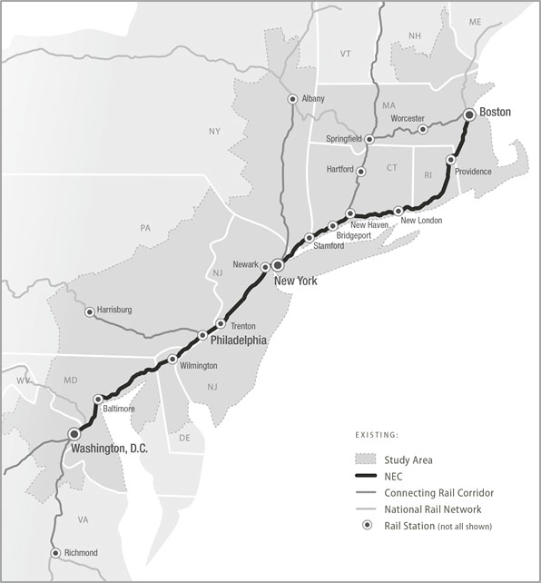
Study Area: The Study Area (Figure
2-1) includes a broad geographic area, stretching 457 miles from
Washington, D.C., in the south to Boston, MA, in the north, encompassing
50,000 square miles. The analysis of markets and services connecting
to the Northeast Corridor (NEC) considers areas outside of the Study
Area, such as Virginia and New Hampshire.
Figure 2-1: Study Area Map
Source: NEC FUTURE team, 2016
Level of Detail: The level of detail
presented is consistent with a tiered environmental review process.
See Data Sources and Geographic Information System Tools for additional information.
Horizon Year: The horizon year for
the Tier 1 Draft EIS and Final EIS is 2040. As part of a National
Environmental Policy Act (NEPA) analysis, a "horizon year"
is considered when conducting analysis. The horizon year refers
to the future timeframe within which Environmental Consequences
associated with the construction and operation of the No Action
Alternative and Preferred Alternative will be assessed. The horizon
year is considered to be the year through which future population
and employment growth as well as travel demand can be reasonably
forecasted for the No Action Alternative and Preferred Alternative,
though, as with any forecasts, such projections of future population
and employment have some degree of uncertainty.
Conceptual Planning and Design: The
FRA used conceptual-level planning and design to support programmatic
decision-making. The Tier 1 Draft EIS and Final EIS do not consider
specific alignments or service plans but rather evaluate representative
routes and service for planning purposes. More-detailed design and
environmental analysis will be conducted during Tier 2 project studies
to determine specific alignments and service.
Boundaries for Defining Environmental Effects: The FRA developed geographic boundaries to establish existing conditions
and to assess effects of the Action Alternatives evaluated in the
Tier 1 Draft EIS. The same assumptions and boundaries apply to the
evaluation of the Preferred Alternative in the Tier 1 Final EIS:1
Existing NEC refers to the representational
footprint for the NEC developed by the FRA for purposes of analysis
in the Tier 1 Draft EIS and Tier 1 Final EIS in order to understand
the potential effects of the No Action Alternative. It is based
on a standardized width of 150 feet, accounting for a four-track
right-of-way, and includes tracks, ballast, signals, etc. See
Chapter 7, Introduction and Guide to Effects Assessment, for
a more detailed discussion on the approach to evaluating the
No Action Alternative.
Existing Hartford/Springfield Line refers
to the representational footprint of the rail line between New
Haven-Hartford-Springfield. For consistency, the FRA based the
footprint of the Existing Hartford/Springfield Line using the
same standardized width (150 feet) used to define the footprint
of the Existing NEC, accounting for a four-track right-of-way,
and inclusive of tracks, ballast, signals, etc.
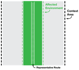
Representative Route is the physical footprint
of improvements and route, associated with an Action Alternative,
including the Preferred Alternative. The dimensions of the Representative
Route's footprint are based on cross sections identifying construction
type (e.g., tunnel, viaduct, bridge, embankment, at-grade) that
are applied to topography or land use type, stations, supporting
facilities, and right-of-way requirements. The footprints associated
with the Representative Route range from 150 feet to 300 feet
wide because improvements associated with stations and supporting
facilities (i.e., tracks, platforms, parking) could flare out
beyond the dimensions of the Representative Route. The Representative Route is the basis for the analysis for this Tier 1 EIS. Alternative location options for new segments will be evaluated as part of Tier 2 project studies.
Affected Environment is the geographic
area for which the FRA identified existing conditions and Environmental
Consequences for the Action Alternatives in the Tier 1 Draft
EIS and Final EIS. The width of the Affected Environment varies
based on the specific resource, but at a minimum is 2,000 feet
wide, centered on the Representative Route. Because the Affected
Environment for an alternative is centered on the Representative
Route for that alternative, the Affected Environment boundaries
are different for each alternative. In some cases, where appropriate
to accurately characterize the resource, the Affected Environment
encompasses the entire Study Area.
Context Area is a broader geographic area
that extends beyond the Affected Environment. This area allowed
the FRA to qualitatively evaluate potential shifts in the Representative
Route. The FRA defined the Context Area with a standardized
5-mile-wide uniform width, centered on the Representative Route,
for all resources. For those resources where the Affected Environment
encompasses the entire Study Area, the FRA did not perform Context
Area analysis. Because the Context Area for an alternative is
centered on the Representative Route for that alternative, the
Context Area boundaries are different for each alternative (except
where the Context Area includes the entire Study Area).
Figure 2-2: Illustration
of Representative
Route, Affected
Environment, and Context Area
Figure 2-2 shows the relationship among the Representative Route,
Affected Environment, and Context Area. These areas are all within the
broader Study Area.
Data Sources and Geographic Information System Tools: The FRA analyzed readily available secondary source data
(e.g., geographic information system [GIS]-based, published reports,
technical analyses), and did not conduct fieldwork or subsurface
testing of any kind as part of this Tier 1 Draft EIS or Final EIS.
The FRA created a GIS database for NEC FUTURE in order to compile,
store, and analyze data to use in documenting existing conditions
and the assessment of Environmental Consequences.2 The FRA carefully reviewed these data to ensure a uniform level
of detail, since data were collected from a variety of sources.
The FRA incorporated future-year projections and calculations relative
to population and employment, travel demand, and related topics
developed specifically for NEC FUTURE into the GIS database for
use in resource-specific analyses. This GIS database also included
information that the FRA developed to define the characteristics
of the Preferred Alternative, such as routes, stations, service
types, and frequency. Together, resource-specific data (e.g., land
cover, demographics, and ecological resources) and information about
the Preferred Alternative are layers in the GIS database. The interaction
of these layers defined the Affected Environment and was used to
assess Environmental Consequences.
Effects-Assessment: The FRA used the same effects-assessment
methodologies, data sources, and data sets presented in the Tier
1 Draft EIS to evaluate the Preferred Alternative in the Tier 1
Final EIS. To maintain consistency between the Tier 1 Draft EIS
and Tier 1 Final EIS, the FRA did not replace the 2012 data sets
used for analysis with more current data sets. However, the FRA
updated some data calculations between the Tier 1 Draft EIS and
Tier 1 Final EIS to respond to comments received during the public
comment period and to address inconsistencies or omissions in data.
Examples of where FRA updated data calculations include the following:
The FRA identified data inconsistencies and omissions in
Chapter 7.2, Land Cover, Chapter 7.6, Ecological Resources,
Chapter 7.9, Cultural Resources, and Chapter 7.11, Environmental
Justice.
The FRA adjusted the NEC FUTURE Interregional Model—a
ridership forecasting tool used for service planning—based
on issues identified during the Tier 1 Draft EIS comment period
and a reassessment of the overall model outcomes (see Chapter
5, Transportation, and Appendix BB, Technical Analysis on the
Preferred Alternative).
The FRA found inconsistencies in the station list (Volume
2, Chapter 4) and has updated the station list for the Preferred
Alternative.
Evaluation of the No Action Alternative: The
definition of the No Action Alternative has not changed between
the Tier 1 Draft EIS and Tier 1 Final EIS. Similarly, the approach
to the analysis of the No Action Alternative has not changed. The
No Action Alternative encompasses existing and planned service improvements,
as well as modified and new infrastructure. Because the physical
limits of the specific improvements that will be made under the
No Action Alternative are unknown, the FRA did not assess the footprint-related
effects of the No Action Alternative quantitatively. Instead, for
the Tier 1 Draft EIS, the FRA developed a representational footprint
for the Existing NEC and used that to understand potential environmental
consequences to resources that could be physically affected by projects
that will be implemented under the No Action Alternative. For the
Tier 1 Final EIS, the FRA modified that representational footprint
for the No Action Alternative to include the Existing Hartford/Springfield
Line; thus, for the Tier 1 Final EIS, a representational footprint
for the Existing NEC and Existing Hartford/Springfield Line (Existing
NEC + Hartford/Springfield Line) is used to understand potential
Environmental Consequences to resources that could be physically
affected by projects under the No Action Alternative. As a result,
quantities shown for the Existing NEC + Hartford/Springfield Line
in the Tier 1 Final EIS differ from the quantities shown for the
Existing NEC in the Tier 1 Draft EIS.
Based on planned projects
defined under the No Action Alternative, the FRA did quantify service-related
effects of the No Action Alternative. For a definition of the No
Action Alternative, refer to Chapter 4, Preferred Alternative, and
Volume 2, Appendix B. For more detail on how the FRA evaluated the
No Action Alternative, see Chapter 7, Introduction and Guide to
Effects Assessment.
2.2.2 Evaluation of the Preferred Alternative
Information presented in the Tier 1 Final EIS evaluates and compares
the Preferred Alternative to the No Action Alternative (Volume 1) using
the same metrics and resource categories used to compare the other Action
Alternatives in the Tier 1 Draft EIS (see Volume 2). The FRA's evaluation
of the Preferred Alternative also employed the same key concepts noted
in Section 2.2.1 (Representative Route, Affected Environment, etc.).
Chapter 4, Preferred Alternative, defines the physical and service elements
of the Preferred Alternative.
2.2.3 Tier 1 EIS Terminology
As appropriate, the FRA defines specific terms relevant to the No
Action Alternative and Action Alternatives in the relevant chapter or
section. The following terms are fundamental to the initial description
of the Study Area and its available passenger services:
NEC (also referred to as the NEC Spine)
is the existing rail transportation spine of the Northeast region—anchored
by Washington Union Station in the south and Boston South Station
in the north. NEC connecting corridors refer to
those rail corridors that connect directly to a station on the NEC.
These include (1) corridor service south of Washington Union Station
to markets in Virginia (i.e., Lynchburg, Richmond, Newport News,
Norfolk) and North Carolina (i.e., Charlotte); (2) Keystone (connects
Philadelphia 30th Street Station to Harrisburg Station); (3) Empire
(connects Penn Station New York to Niagara Falls Station); and (4)
Hartford/Springfield Line (connects New Haven Union Station to Springfield
Union Station with connections north and east of Springfield, MA).
The NEC Rail Network refers to the NEC Spine and
its connecting corridors.
Regional refers to traditional peak or off-peak
commuter or regional travel, generally defined by trips that start
or end within the same metropolitan area. Regional trips are typically
served by commuter or regional railroads within a metropolitan area or within a state (e.g., Baltimore, MD
to Washington, D.C., New Brunswick, NJ to New York City, or Providence
to Boston, MA). Throughout the Tier 1 Final EIS, commuter or regional
railroads are referred to as Regional rail.
Interregional generally refers to trips that
start or end in different metropolitan areas (e.g., Washington,
D.C. to New York City, Philadelphia to New York City, or New Haven,
CT to Boston, MA). Interregional trips are generally served by Intercity railroads (Amtrak), offering services
that connect cities or metropolitan areas at speeds and distances
greater than that of commuter rail.
Metropolitan refers to limited-stop, service
for longer-distance trips between broad metropolitan areas or trips
connecting secondary markets. It is a new service concept that upgrades
the level of Intercity-Corridor rail service provided on the NEC,
offers frequent service (2—4 trains per hour) to large and mid-size
markets and key transfer locations, and stops at more stations than
current Intercity service.
Intercity-Express refers to premium Intercity
high-speed rail service offered on the NEC, making limited stops
along the NEC serving the largest markets only. Amtrak's Acela Express
provides such service on the NEC between Washington, D.C., and Boston.
Intercity-Express service offers the shortest travel times for Intercity
trips, with a higher quality of onboard amenities, at a premium
price, using state-of-the-art high-speed trainsets.
No Action Alternative defines conditions that
will exist in the 2040 analysis year if the proposed action is not
implemented. (Under NEPA, the No Action Alternative is sometimes
referred to as the No Build condition.) For NEC FUTURE, the No Action
Alternative is a baseline against which the FRA compares the effects
of the Preferred Alternative. The No Action Alternative represents
the condition of the Northeast region's multimodal transportation
system in 2040.
Action Alternatives refers to the action or
build alternatives considered and evaluated in the Tier 1 Draft
EIS. The Action Alternatives considered a range of service improvements
to both regional and interregional travel and inclusion of new markets.
See Volume 2, Chapter 4, Alternatives Considered, for a description
of each Action Alternative.
The Preferred Alternative includes the following:
Improvements to the existing NEC; the existing NEC is never
abandoned.
RepresentativeService Plans developed
in coordination with stakeholders for the purposes of analysis.
Representative Routes connecting geographic markets
and providing chokepoint relief and increased capacity along
the existing NEC.
Preferred Alternative refers to the alternative identified by the FRA after the evaluation of the alternatives in the Tier 1 Draft EIS and public comment period. The Preferred Alternative comprises elements evaluated throughout the alternatives development process for NEC FUTURE. It generally represents the “grow” vision described for Alternative 2 presented in the Tier 1 Draft EIS (see Volume 2, Chapter 4). The Representative Route of the Preferred Alternative includes a combination of the Existing NEC and new segments evaluated as part of the Action Alternatives in the Tier 1 Draft EIS.
The Preferred Alternative representative routes and construction characteristics are the basis for the analysis in the NEC FUTURE Tier 1 EIS. They illustrate necessary improvements to achieve the Preferred Alternative service and performance objectives. As part of the Tier 1 process, the FRA has determined the necessity for new segments in particular geographic sections of the NEC in order to meet the Purpose and Need, and has identified a representative route for each potential new segment. The FRA or another federal agency providing funding for a particular project will evaluate specific locations for new segments as part of the Tier 2 project studies, prior to making any decision regarding new segment locations.
The southern
terminus of the Preferred Alternative is Washington Union Station
in Washington, D.C. Service splits at New Haven, CT, with some service
continuing along an improved NEC to South Station in Boston and
the remaining service continuing along an electrified Hartford/Springfield
Line. Several new segments are provided along the Preferred Alternative
to relieve chokepoints and to increase capacity of the existing NEC.
Selected Alternativerefers to an alternative to be selected in the ROD. The Selected Alternative documented in the ROD may or may not be the same as the Preferred Alternative described in this Tier 1 Final EIS. As in any NEPA process, it also is possible that the Record of Decision will result in selection of the No Action Alternative.
Chapter 4, Preferred Alternative, provides a more detailed geographic
description of the No Action Alternative and Preferred Alternative.
2.3 Contents of Volume 1
2.3.1 Main Body
Following the Introduction (Chapter 1) and the Readers' Guide (Chapter 2), the main body of Volume
1 (Preferred Alternative) includes the following:
Purpose and Need (Chapter 3) summarizes the
Purpose and Need presented in Volume 2, Chapter 3.
Preferred Alternative (Chapter 4) provides
the definition of the Preferred Alternative, including representative
service characteristics and a Representative Route. It also presents
the rationale for the definition of the Preferred Alternative.
Transportation (Chapter 5) analyzes regional
and local effects of the No Action Alternative and Preferred Alternative
on the multimodal transportation network, including changes in mode
of travel, volume of travel, and services offered.
Economic Effects and Growth, and Indirect Effects (Chapter
6) analyzes direct and indirect economic and induced growth
effects of the No Action Alternative and Preferred Alternative,
including employment, construction activity, monetized total values
for transportation effects, and long-term market effects.
Affected Environment, Environmental Consequences, and
Mitigation (Chapter 7) analyzes existing conditions and
potential effects of the No Action Alternative and Preferred Alternative
on the built and natural environments.
Construction Effects (Chapter 8) presents an
overview of the potential construction activities associated with
the Preferred Alternative and related short-term effects associated
with those activities.
Evaluation of the Preferred Alternative (Chapter 9) compares the Preferred Alternative to the No Action Alternative
based on a range of metrics to evaluate how well the No Action Alternative
and Preferred Alternative perform relative to service, operations,
ridership, economic benefits, environmental effects, and other evaluation
criteria.
Phasing and Implementation of Alternatives (Chapter
10) describes the process to work with stakeholders to
define the Initial Phase for the Selected Alternative (the alternative
ultimately selected by the FRA in the Record of Decision).
Agency and Public Involvement (Chapter 11) summarizes agency and public involvement activities undertaken since
publication of the Tier 1 Draft EIS. This chapter summarizes the
public hearings and comments on the Tier 1 Draft EIS.
References (Chapter 12) lists sources and references
for the analysis and documentation presented.
Glossary (Chapter 13) explains terminology
and acronyms used throughout this Tier 1 Final EIS.
List of Preparers (Chapter 14) identifies persons
involved in the analysis and development of this Tier 1 Final EIS.
Index (Chapter 15) guides the reader in finding
specific items within this Tier 1 Final EIS.
2.3.2 Appendices
The appendices presented in Volume 1 are comparable to the supporting
documentation presented for Volume 2. For Volume 1, appendices are identifiable
by double lettering that match the lettering and organization of the
appendices presented with Volume 2. For example, the Mapping Atlas in
Volume 2 is identified as Appendix A; for Volume 1 it is identified
as Appendix AA. The following appendices provide the detailed technical
documentation, calculations, and relevant coordination materials that
support the findings presented in Volume 1:
Appendix AA, Mapping Atlas of the Preferred Alternative, presents maps from south to north and allows the reader
to follow the Preferred Alternative along its Representative Route
from Washington, D.C., to Boston and from New Haven through Hartford,
CT, and to Springfield, MA, in relation to mapped resources. The
atlas highlights areas where new infrastructure is proposed for
the Preferred Alternative and coincides with the discussed mapped
resources (Part 1). It also provides a separate map series that
highlights the Representative Route construction types used for
analytical purposes (Part 2).
Appendix BB, Technical Analysis on the Preferred Alternative, provides the documentation that supports the deliberative process
to identify the Preferred Alternative as presented in Chapter 4.
Appendix CC, Transportation Effects of the Preferred
Alternative, provides information on the representative
stations used in the analysis presented in Chapter 5, Transportation.
The analysis of transportation effects relies on the technical analysis
of the Preferred Alternative presented in Appendix BB.
Appendix DD, Economic Effects of the Preferred Alternative, provides the technical data that supports the economic
effects and indirect effects analyses presented in Chapter 6.
Appendix EE, Environmental Resource Documentation for
the Preferred Alternative, provides detailed documentation
that supports Chapter 7. Each resource presented in Chapter 7 has
its own corresponding section within Appendix EE; each of these
sections is organized geographically for the existing NEC and Preferred
Alternative to provide more-detailed information at the state and
county level. Note that Appendix E of Volume 2 contains the original
effects-assessment methodologies that describe how effects to the
various resources in Chapter 7 were analyzed.
Appendix FF, Agency and Public Involvement, provides supporting documentation for the agency and public involvement
activities and resources described in Chapter 11. Specifically,
the appendix includes information pertaining to various stakeholder
engagements, briefings, and meetings undertaken since the publication
of the Tier 1 Draft EIS, public hearings, and the distribution list
for the Tier 1 Draft EIS. Materials produced prior to the Tier 1
Draft EIS are provided in Appendix F of Volume 2.
Appendix GG, Section 106 Documentation, provides
documentation relevant to compliance with Section 106 of the National
Historic Preservation Act since the publication of the Tier 1 Draft
EIS. Relevant documentation includes a record of the coordination
with State Historic Preservation Offices, the Advisory Council on
Historic Preservation, and Government-to-Government Tribal coordination.
It also provides the executed Programmatic Agreement for NEC FUTURE.
Correspondence prior to the Tier 1 Draft EIS is provided in Volume
2, Appendix G.
Appendix HH, Preliminary Section 4(f) and Section 6(f)
Resources, documents the preliminary assessment and evaluation
of resources protected under Section 4(f) of the U.S. Department
of Transportation Act and Section 6(f) of the Land and Water Conservation
Fund Act that were identified within the Affected Environment and
that could be affected by the Preferred Alternative. Appendix HH
does not represent a Section 4(f) Determination.
Appendix II, Endangered Species Act Correspondence, providesthe correspondence with the U.S.
Fish and Wildlife Service and National Marine Fisheries Service
related to the Endangered Species Act.
Appendix JJ, Comments and Responses, provides
all of the individual comments received on the Tier 1 Draft EIS
and responses to those comments. An index to this appendix is provided
in order to locate individual comments submitted by commenters.
This appendix is only included in Volume 1.
2.4 Contents of Volume 2
Volume 2 contains all of the chapters and appendices comprising the
Tier 1 Draft EIS. The organization of this content has not changed;
all chapter headings have been retained. The FRA has updated the content
for both the main body and appendices to reflect noted changes resulting
from the public comment period.
At the beginning of each chapter and appendix for Volume 2, an errata
sheet is included that either identifies the changes that have been
made to that chapter or notes that no changes were made.
Footnotes
1 The Preferred Alternative repackages
physical and service elements of the Action Alternatives presented in
the Tier 1 Draft EIS. The Preferred Alternative incorporates new segments
proposed with the Action Alternatives and also incorporates the Hartford/Springfield
Line.
2 See Appendix AA, Mapping Atlas
of the Preferred Alternative, and Volume 2, Appendix E, Environmental
Resource Documentation, for GIS sources.
The information posted on this website includes hypertext links or pointers to information created and maintained by other public and/or private organizations. The FRA provides these links and pointers solely for information and convenience. When users select a link to an outside website, they are leaving the NEC FUTURE website and are subject to the privacy and security policies of the owners/sponsors of the outside website. The FRA does not control or guarantee the accuracy, relevance, timeliness or completeness of information contained on a linked website, or endorse the organizations sponsoring linked websites, the views they express, or the products/services they offer. The FRA cannot authorize the use of copyrighted materials contained in linked websites and is not responsible for transmissions users receive from linked websites.