Key Resource: Ecological Resources
Ecological resources include terrestrial and aquatic environments (and the organisms within these environments) that are fundamental for maintaining balanced earth processes. Within the Study Area, ecological resources include forested land, wetlands, and waterways, as well as marine and land-based species. Converting these habitats to transportation use could affect sensitive ecosystems and species. This section describes ecological resources within the Study Area, and identifies potential effects to sensitive habitats and species from the Tier 1 Draft Environmental Impact Statement (Tier 1 Draft EIS) Action Alternatives.
For the purposes of this analysis, the Federal Railroad Administration (FRA) defines ecological resources as the following:
The FRA developed an effects-assessment methodology for each resource area analyzed in this Tier 1 Draft EIS. (See Appendix E, Section E.06, for the Ecological Resources Methodology.) The Ecological Resource Methodology and the methodology update (also provided in Appendix E, Section E.06) provide the data sources of each resource, an explanation on how the FRA defined and established the Affected Environment, and information on how the FRA evaluated and reported the effects on each resource. Table 7.6-1 summarizes key information associated with the analysis of each evaluated ecological resource.
| Resource | Affected Environment | Type of Assessment | Outcome |
|---|---|---|---|
| Ecologically Sensitive Habitat (ESH) | 3,000-foot-wide swath centered along Representative Route for each Action Alternative | Quantitative: Acres | Identification of ESH including parks, forests, wetlands, streams and coastal areas that could be affected by the Representative Routes of the Action Alternatives |
| Threatened and Endangered (T&E) Species | Qualitative: Occurrence | Identification of federally listed T&E species and their critical habitats that could be affected by the Representative Routes of the Action Alternatives | |
| Essential Fish Habitat (EFH) | Quantitative: Number/Acres/ Linear feet | Identification of federally managed fish species that could be affected by the Representative Routes of the Action Alternatives by waterbody crossings |
Source: NEC FUTURE Ecological Resources Assessment Methodologies, Appendix E, Section E.06, 2014
Understanding locations of ecologically sensitive resources is an important consideration in identifying a Preferred Alternative. Many ecologically sensitive resources provide for foraging by wildlife species and habitat. Various federal, state, and local laws and regulations protect many of these ecologically sensitive areas and resources. As such, impacts to the resources may present permitting challenges that could prevent implementation of an action. This Tier 1 Draft EIS analysis identifies the locations of and the potential for impacts to ecologically sensitive resources associated with the Action Alternatives. More site-specific analysis at future stages of program development is required to determine the extent of impacts on ecologically sensitive resources.
In general, the Study Area consists of many undeveloped terrestrial habitats, including forests, parks, and refuges. Aquatic ecological resources include waterbodies that are located along coastlines and inland, including estuaries, inlets, bays, and rivers. Impacts to these sensitive habitats and the species that occur in these habitats would result from the construction and operation of the Action Alternatives, and include the following:
The FRA identified ecological resources within the Affected Environment and Representative Routes for each of the Action Alternatives. Table 7.6-2 through Table 7.6-6 summarize the ESHs, T&E species, and federally-managed fish species and EFHs within the Affected Environment and Representative Routes of the Action Alternatives. (See Appendix E, Section E.06, for a complete list of all identified ecological resources broken down by ESH, T&E, and EFH.)
Ecological resources occur throughout the Study Area but higher concentrations tend to occur in Connecticut, Rhode Island, New York, and Maryland. States with the most ESH tend to include large, undeveloped ESH areas with comparably small, concentrated metropolitan centers. Connecticut is one of the geographically larger states with substantial tracts of contiguous forested and undeveloped land and therefore tends to have the most ecologically sensitive resources. Also, much of the Representative Routes of the Action Alternatives within Connecticut lie within the state's long coastline. Maryland, New York, and Rhode Island also have relatively higher ESH quantities across the Action Alternatives, attributed in part to the large tracts of contiguous undeveloped terrestrial ESHs, the numerous waterbodies, and large spans of coastline located within the Representative Routes of the Action Alternatives in each of these states. In contrast, Washington, D.C., tends to have the fewest ecological resources since it is a highly developed and relatively small geographic area.
The following are the key findings of the analysis:
The FRA identified ESH by creating a single ESH GIS data layer using federal GIS data sources. This ESH layer consisted of three categories of ESHs: terrestrial, saltwater aquatic, and freshwater aquatic. The FRA quantitatively and qualitatively assessed ESHs within the Affected Environment, including ESH by type (terrestrial, aquatic) and acreage. Appendix E, Section E.06, contains further details.
By state, Connecticut contains the most ESH acreage for all the Action Alternatives within the Affected Environment, including the most total ESH (Alternative 3), and the most terrestrial (Alternative 1), and saltwater and freshwater ESH acreages (across all Action Alternatives). New London and New Haven Counties, CT, consistently contain more terrestrial and saltwater ESH, resulting from all the Action Alternatives running along the Connecticut coastline where these counties are located.
Across all the Action Alternatives, Bucks County, PA, has the most freshwater ESH and Washington, D.C., has the least ESH acreage within the Affected Environment, including the least total, terrestrial, and total combined aquatic ESH (Table 7.6-2).
| Geography | Existing NEC (acres) |
Alternative 1 (acres) |
Alternative 2 (acres) |
Alternative 3 (acres) |
|---|---|---|---|---|
| D.C. | 230 | 230 | 230 | 235 |
| MD | 8,850 | 8,895 | 11,440 | 14,690 |
| DE | 1,585 | 1,585 | 2,085 | 1,955 |
| PA | 2,055 | 2,055 | 2,495 | 2,895 |
| NJ | 4,775 | 4,775 | 4,855 | 5,050 |
| NY | 1,155 | 1,155 | 1,240 | 3,405-8,235 |
| CT | 11,065 | 16,330 | 2,5270 | 23,525-31,520 |
| RI | 5,965 | 7,255 | 11,040 | 5,965-11,040 |
| MA | 4,415 | 4,415 | 4,780 | 4,870-14,125 |
| TOTAL | 40,095 | 46,695 | 63,435 | 70,075-82,250 |
Source: NEC FUTURE team, 2015
The general trend for more ESH acreage within the Affected Environment in Alternative 3, and less ESH acreage recorded for the existing NEC and Alternatives 1 and 2 is attributed to the large tracts of undeveloped terrestrial ESHs, and the quantity and size of the waterbodies that Alternative 3 passes through in multiple states. (See Appendix A, Mapping Atlas, for ESH locations.)
Appendix E, Section E.06, shows, by county and state, the Threatened and Endangered (T&E) species and their federally designated critical habitats, if applicable, potentially occurring within the Affected Environment and Context Area for each of the Action Alternatives. The table identifies federally listed T&E species, their status as either "T" or "E," the type of species (e.g., plant, mammal, reptile), habitat description and location/range, and federally designated critical habitats.
Twenty-four (24) federally listed T&E species and their habitats potentially exist within the Affected Environment/Representative Routes of the Action Alternatives (Table 7.6-3). Species types include plants, fish, reptiles, mammals, birds, and insects.
| Scientific Name | Common Name | Species Type | Threatened or Endangered | States Where Species Occur |
|---|---|---|---|---|
| Charadrius melodus | Piping Plover | Bird | T | NY, CT, RI, MA |
| Calidris canutus rufa | Rufa Red Knot* | Bird | T | MA |
| Myotis septentrionalis | Northern Long-Eared Bat* | Mammal | T | NJ, NY |
| Cicindela puritana | Puritan Tiger Beetle | Insect | T | CT |
| Amaranthus pumilus | Seabeach Amaranth | Plant | T | NY |
| Isotria medeoloides | Small Whorled Pogonia | Plant | T | CT, RI |
| Helonius bullata | Swamp Pink | Plant | T | MD, NJ |
| Clemmys muhlenbergii | Bog Turtle | Reptile | T | MD, DE, PA, NJ, NY, CT |
| Chelonia mydas | Green Sea Turtle | Reptile | T | NY, CT |
| Caretta caretta | Loggerhead Sea Turtle | Reptile | T | NY, CT |
| Sterna dougallii dougalli | Roseate Tern | Bird | E | NY, CT, RI, MA |
| Acipenser oxyrinchus oxyrinchus | Atlantic Sturgeon | Fish | E | DE, PA, NJ, NY, CT, MA |
| Etheostoma sellare | Maryland Darter | Fish | E | MD |
| Acipenser brevirostrum | Shortnose Sturgeon | Fish | E | MD, DE, PA, NJ, NY, CT, MA |
| Balaenoptera musculus | Fin Whale | Mammal | E | CT |
| Megaptera novaeangliae | Humpback Whale | Mammal | E | CT |
| Myotis sodalist | Indiana Bat | Mammal | E | PA, NJ, NY, CT |
| Eubalaena glacialis | Right Whale | Mammal | E | CT |
| Alasmidonta heterodon | Dwarf Wedgemussel | Mussel (freshwater) | E | CT |
| Agalinis acuta | Sandplain Gerardia | Plant | E | MD, CT, RI |
| Eretmochelys imbricate | Hawksbill Sea Turtle | Reptile | E | CT |
| Lepidochelys kempii | Kemp's Ridley Sea Turtle | Reptile | E | CT |
| Dermochelys coriacea | Leatherback Sea Turtle | Reptile | E | CT |
| Pseudemys rubriventris bangsi | Plymouth Red-Bellied Cooter | Reptile | E | MA |
Source: NEC FUTURE team, 2015
Note: Species/habitat listed are identified as a species/areas of concern. Species/habitats identified as "species/habitat that needs no further evaluation" are not included in the Tier 1 Draft EIS but are listed in Appendix E, Section E.06, T&E data table.
* Newly listed species were reviewed corridor-wide for species occurrence.
In general, most states host the occurrence of 4 to 7 species across the Affected Environment of the Action Alternatives. However, Connecticut and New York have higher numbers of T&E species/habitats within the Affected Environment. Compared to all other states, Connecticut has the most T&E species potentially within the Affected Environment for every Action Alternative. Connecticut has 18 T&E species potentially within the Affected Environment for the existing NEC as well as Alternatives 1 and 2, and 19 T&E species potentially within the Affected Environment for Alternative 3. Of these totals, 13 -14 of these T&E species are found within the Affected Environment in New Haven and Fairfield Counties for all Action Alternatives. New York has 18 T&E species potentially within the Affected Environment for Alternative 3; 16 of these T&E species are situated in Suffolk County. Across all Action Alternatives, Washington, D.C., has the fewest T&E species, with 1 T&E species potentially occurring within the Affected Environment (Table 7.6-4).
| Geography | Existing NEC (occurrence) |
Alternative 1 (occurrence) |
Alternative 2 (occurrence) |
Alternative 3 (occurrence) |
|---|---|---|---|---|
| D.C. | 1 | 1 | 1 | 1 |
| MD | 5 | 5 | 5 | 5 |
| DE | 4 | 4 | 4 | 4 |
| PA | 5 | 5 | 5 | 5 |
| NJ | 7 | 7 | 7 | 7 |
| NY | 7 | 9 | 9 | 9-19 |
| CT | 18 | 18 | 18 | 19 |
| RI | 5 | 5 | 4 | 5 |
| MA | 6 | 6 | 5 | 6 |
Source: NEC FUTURE team, 2015
Note: Totals for Action Alternative are not counted since species occur in multiple states per Action Alternative.
Additional Species under Consideration
The New England Cottontail (Sylvilagus transitionalis), Monarch Butterfly (Danaus plexippus), Dusky Shark (Cacharhinus obscures), and Cusk (Brosme brosme) are four species identified for continued monitoring of their Endangered Species Act (ESA) status and occurrence within the Study Area. A final determination assessment has been completed for the Rufa Red Knot (Calidris canutus rufa) and Northern Long-Eared Bat (Myotis septentrionalis). The Rufa Red Knot was listed as of January 2015, and the Northern Long-Eared Bat was listed as of May 4, 2015. These species are included in this Draft Tier 1 EIS T&E analysis.
Within the Affected Environment of the Action Alternatives, 21 federally managed fish species occur in 32 waterbodies (Table 7.6-5). Essential Fish Habitat (EFH) is defined by the federally managed fish species (including all life stages, spawning, breeding, and migratory patterns) that inhabit a particular EFH. In many cases, an EFH may have more than one fish species occurrence. For example, multiple federally managed fish species inhabit the Boston Harbor and/or Long Island Sound as described in Table 7.6-5.
| Scientific Name | Common Name | Waterbody |
|---|---|---|
| Pomatomus saltatrix | Bluefish | Chesapeake Bay, Delaware River, East River, Eastchester Bay, Long Island Sound, Housatonic River, Quinnipiac River, Branford River, West River, Connecticut River, Thames River, Narragansett Bay, Providence River, Seekonk River, Boston Harbor |
| Paralichthys dentatus | Summer Flounder | Chesapeake Bay, Delaware River, Raritan River, Newark Bay, Arthur Kill, Passaic River, Hackensack River, Hudson River, East River, Upper New York Bay, Eastchester Bay, Long Island Sound, Housatonic River, Quinnipiac River, Branford River, West River, Connecticut River, Thames River, Narragansett Bay, Providence River, Seekonk River |
| Scophthalmus aquosus | Window Pane Flounder | Chesapeake Bay, Newark Bay, Arthur Kill, Passaic River, Hackensack River, Hudson River, Jamaica Bay, Eastchester Bay, Long Island Sound, Branford River, Connecticut River, Narragansett Bay, Providence River, Boston Harbor |
| Centropristis striata | Black Sea Bass | Delaware River, East River, Eastchester Bay, Long Island Sound, Housatonic River, Quinnipiac River, Branford River, West River, Long Island Sound, Connecticut River, Thames River, Narragansett Bay, Providence River, Seekonk River |
| Stenotomus chrysops | Scup | Delaware River, East River, Eastchester Bay, Long Island Sound, Housatonic River, Quinnipiac River, Branford River, West River, Long Island Sound, Connecticut River, Thames River, Narragansett Bay, Providence River, Seekonk River |
| Peprilus triacanthus | Atlantic Butterfish | Jamaica Bay, Long Island Sound, Narragansett Bay, Housatonic River, West River, East River, Quinnipiac River, Farm River, Branford River, Hammonasset River, Indian River, Hammock River, Menunketesuck River, Oyster River, Connecticut River, Niantic River, Thames River |
| Scomber scombrus | Atlantic Mackerel | Long Island Sound |
| Clupea harengus | Atlantic Herring | Newark Bay, Arthur Kill, Passaic River, Hackensack River, Hudson River, Jamaica Bay, Eastchester Bay, Long Island Sound, Branford River, Connecticut River, Narragansett Bay, Providence River, Boston Harbor |
| Urophycis chuss | Red Hake | Newark Bay, Arthur Kill, Passaic River, Hackensack River, Hudson River, Jamaica Bay, Eastchester Bay, Long Island Sound, Branford River, Connecticut River, Narragansett Bay, Providence River, Boston Harbor |
| Pseudopleuronectes americanus | Winter Flounder | Boston Harbor |
| Leucoraja erinacea | Little Skate | Jamaica Bay, Eastchester Bay, Long Island Sound, Housatonic River, Quinnipiac River, Branford River, West River, Narragansett Bay, Providence River |
| Merluccius bilinearis | Silver Hake/Whiting | Jamaica Bay, Long Island Sound, Branford River, Boston Harbor |
| Leucoraja ocellata | Winter Skate | Jamaica Bay, Eastchester Bay, Long Island Sound, Housatonic River, Quinnipiac River, Branford River, West River |
| Pollachius pollachius | Pollock | Eastchester Bay, Long Island Sound, Branford River, Connecticut River, Boston Harbor |
| Zoarces americanus | Ocean Pout | Long Island Sound, Boston Harbor |
| Melanogrammus aeglefinus | Haddock | Long Island Sound, Narragansett Bay, Providence River, Boston Harbor |
| Gadus morhua | Atlantic Cod | Boston Harbor |
| Hippoglossoides platessoides | American Plaice | Boston Harbor |
| Urophycis tenuis | White Hake | Boston Harbor |
| Limanda ferruginea | Yellowtail Flounder | Boston Harbor |
| Loligo pealeii | Longfin Inshore Squid | Newark Bay, Arthur Kill, Jamaica Bay, Eastchester Bay, Long Island Sound, Branford River, East River, Connecticut River, Thames River, Pawcatuck River, Narragansett Bay, Providence River |
Source: NEC FUTURE team, 2015
Across all Action Alternatives, Connecticut has the most federally managed fish species occurrences within the Affected Environment, with 16 species per Action Alternative (Table 7.6-6). Of this total, Fairfield County, CT, has the most federally managed fish species occurrences in the Affected Environment, with 15 species associated with all Action Alternatives. Suffolk County, NY, and New London and Fairfield Counties, CT, also have higher numbers of fish species occurrences in the Affected Environment, with 14 federally managed fish species associated with Alternative 3 in Suffolk and Fairfield Counties, and 14 species for all the Action Alternatives through New London County. The disproportionate level of federally managed fish species in Connecticut results from the many ESHs-inlets and waterbodies-located proximate to the Connecticut shoreline and within the Affected Environment of all the Action Alternatives.
| Geography | Existing NEC | Alternative 1 | Alternative 2 | Alternative 3 |
|---|---|---|---|---|
| D.C. | 0 | 0 | 0 | 0 |
| MD | 3 | 3 | 3 | 3 |
| DE | 4 | 4 | 4 | 4 |
| PA | 0 | 0 | 0 | 0 |
| NJ | 1 | 1 | 1 | 1 |
| NY | 13 | 13 | 13 | 13-14 |
| CT | 16 | 16 | 16 | 16 |
| RI | 13 | 13 | 13 | 13 |
| MA | 13 | 13 | 13 | 13 |
Source: NEC FUTURE team, 2015
A sharp increase in possible species occurrence from New York north to Massachusetts is the result of the Affected Environment route passing through the Long Island Sound and the length of the Connecticut coastline. Many federally managed fish species and protected marine mammal species occur and migrate through the Long Island Sound. Similarly, the Connecticut coastline has an extensive shoreline with many inlets containing higher concentrations of federally managed fish species and protected marine mammals.
Other Aquatic Resources of Concern/Consideration
The FRA is coordinating with the National Marine Fisheries Service (NMFS) regarding EFH and federally managed fish species associated with the Action Alternatives. In addition to those fish species listed in Table 7.6-5, the NMFS has identified other sensitive marine species for consideration. The NMFS identified and recommended consideration of a number of "species of concern" that are not federally managed species (and therefore are not included in the federally managed fish species list) but are wetland, waterway, and/or important foraging species about which the agency has insufficient information and/or concerns regarding status and threats. Table 7.6-7 lists these species of concern that should be further examined during the Tier 2 environmental compliance processes. The NMFS is also working with the U.S. Fish and Wildlife Service (USFWS) on investigating a number of sensitive species. The NMFS and USFWS are jointly conducting a status review of the American Eel (Anguilla rostrata) listed in Table 7.6-7, to determine if listing the eel as endangered or threatened is warranted. As mentioned in Section 7.6.3.2, the Dusky Shark (Cacharhinus obscures) and Cusk (Brosme brosme) are candidate species currently undergoing a status review for potential ESA listing. The Dusky Shark is also listed as an NMFS federally managed species. The NMFS has identified these two species as species of concern since they inhabit the coastal waters of the Greater Atlantic region and could occur within the Study Area. The FRA did not evaluate these two species as part of this Tier 1 Draft EIS; based on readily available data, they do not fall within the Affected Environment of the Action Alternatives. These species would be monitored for status and investigated further during the Tier 2 environmental compliance processes based on updated/revised data and continued coordination with the NMFS.
The NMFS recommended consideration of three federally managed whale species under the Marine Mammal Protection Act not included in the federally managed fish species list (Appendix E, Section E.06). The Sei (Balaenoptera borealis), Sperm (Physeter macrocephalus), and Blue (Balaenoptera musculus) whales (all endangered species protected under the ESA) generally inhabit the offshore waters of the Greater Atlantic region and are not expected to occur in the coastal waters where the Action Alternatives primarily run. However, these whales' habitats extend throughout the region, and as a result, NMFS has identified them as potential species for consideration.
The NMFS also recommended consideration of four federally managed fish species not included in the EFH table in Appendix E, Section E.06. The King Mackerel (Scoberomorus cavalla), Spanish Mackerel (Scoberomorus maculates), and Cobia (Rachycentron canadum) predominantly inhabit the South Atlantic region waters and are not expected to occur near the Study Area. However, these species are also species of consideration by the NMFS because of their extended habitat range into the offshore waters of the Mid-Atlantic region. The Clearnose Skate (Raja eglanteria) was analyzed and ultimately determined outside of the Action Alternatives' Affected Environment; as such, it is not considered further as part of this analysis.
These whale and fish species would be investigated further during the Tier 2 environmental compliance processes, but are not anticipated to be affected.
| Scientific Name | Common Name | Special Designation |
|---|---|---|
| Alosa pseudoharnegus | Alewife | NMFS species of concern1 |
| A. aestivalis | Blueback Herring | |
| A. sapidissima | American Shad | None2 |
| Morone saxatilis | Striped Bass | |
| Perca flavescens | Yellow Perch | |
| Alosa mediocris | Hickory Shad | |
| Trinectes maculatus | Hogchoker | |
| Fundulus diaphanous | Banded Killifish | |
| Fundulus heteroclitus | Mummichog | |
| Clupea harengus | Atlantic Herring | |
| Brevoortia tyrannus | Atlantic Menhaden | |
| Anchoa mitchilli | Bay Anchovy | |
| Dorosoma cepedianum | Gizzard Shard | |
| Morone Americana | White Perch | |
| Menidia menidia | Atlantic Silverside | |
| Menidia beryllina | Inland Silverside | |
| Leiostomus xanthurus | Spot | |
| Fundulus majalis | Striped Killifish | |
| Anguilla rostrata | American Eel | Undergoing ESA status review in cooperation with the USFWS3 |
| Carcharhinus obscurus | Dusky Shark | ESA candidate species, NMFS species of concern 4 |
| Brosme brosme | Cusk |
Sources:
1 NMFS Species of Concern list (http://www.nmfs.noaa.gov/pr/species/concern/). These species are listed in the NMFS correspondence.
2 Species listed in NMFS correspondence to project, "Ecological Resources Effects Assessment Coordination Relative to Section 7 of the Endangered Species Act," received December 19, 2014. The NMFS has concerns over these species, but they are not "Species of concern" or "EFH species."
3 Species under review for ESA designation (http://ecos.fws.gov/speciesProfile/profile/speciesProfile.action?spcode=E0AG). Species is listed in NMFS correspondence.
4 NMFS federally managed species (Dusky Shark only), and Candidate and Proposed Species under the Endangered Species Act list (http://www.nmfs.noaa.gov/pr/species/esa/candidate.htm). These species are also listed in the NMFS correspondence.
The NMFS identified one species included in the NEC FUTURE T&E species list that may be eliminated from further investigations. The Hawksbill Sea Turtle (Eretmochelys imbricate) is an endangered species and included in the T&E species Table 7.6-3 as potentially occurring within the Affected Environment. The NMFS indicated that this species is not expected to occur in the Affected Environment and may therefore be eliminated as a potential project species of concern. The Hawksbill Sea Turtle would be investigated during the Tier 2 environmental compliance processes, and a final determination will be made as to whether the turtle warrants exclusion from future project consideration.
The NMFS has requested in correspondence that the Distinct Population Segment (DPS) for the Atlantic Sturgeon be included on the T&E species list. The Atlantic Sturgeon is a listed endangered species under USFWS jurisdiction and is composed of five DPSs, divided by the sturgeon's species range. The NMFS has indicated that wherever the sturgeon is listed for potential occurrence, its associated DPS should also be included. The recommendation to make this distinction has been noted and would be conducted during the Tier 2 environmental compliance processes.
The FRA quantitatively and qualitatively assessed Environmental Consequences for ESH by type and acreage of impact within the Representative Route. The assessment includes identification of, and discussion of impacts (including habitat fragmentation impacts) on, those ESH areas where 10 percent or greater of the total area of the ESH is potentially impacted.
Based on GIS analysis, the FRA identified ESH areas within the Representative Route for the Action Alternatives. The regions with the most and least area (acreage) of total ESH-further sub-categorized by terrestrial, freshwater, and saltwater-were determined by state and county for each Action Alternative. Table 7.6-8 and Table 7.6-9 summarize the results of the ESH analysis by Action Alternative.
| Geography | Existing NEC | Alternative 1 | Alternative 2 | Alternative 3 |
|---|---|---|---|---|
| D.C. | 5 | 5 | 5 | 20 |
| MD | 205 | 205 | 330 | 970 |
| DE | 25 | 25 | 70 | 160 |
| PA | 25 | 25 | 60 | 140 |
| NJ | 105 | 110 | 135 | 460 |
| NY | 50 | 50 | 60 | 220-430 |
| CT | 370 | 605 | 1,155 | 890-1,390 |
| RI | 175 | 300 | 435 | 175-445 |
| MA | 170 | 170 | 215 | 530-730 |
| TOTAL | 1,130 | 1,495 | 2,465 | 3,750-4,540 |
Source: NEC FUTURE team, 2015
| Geography | Existing NEC | Alternative 3 | ||||
|---|---|---|---|---|---|---|
| D.C. to NYC | New York City to Hartford | Hartford to Boston | ||||
| via Central Connecticut | via Long Island | via Providence | via Worcester | |||
| D.C. | 5 | 20 | - | - | - | - |
| MD | 205 | 970 | - | - | - | - |
| DE | 25 | 160 | - | - | - | - |
| PA | 25 | 140 | - | - | - | - |
| NJ | 105 | 460 | - | - | - | - |
| NY | 50 | - | 430 | 420 | - | - |
| CT | 370 | - | 610 | 460 | 780 | 425 |
| RI | 175 | - | - | - | 445 | 175 |
| MA | 170 | - | - | - | 530 | 730 |
| TOTAL | 1,130 | 1,750 | 1,040 | 680 | 1,750 | 1,330 |
Source: NEC FUTURE team, 2015
- = Not applicable within that alternative/option.
Consistent with the Affected Environment, Representative Routes associated with Alternative 3 generally would have the most impacts to ESH areas throughout the Study Area compared to the No Action and Alternatives 1 and 2 (Table 7.6-8).
Most of the ESH impacts by state would be concentrated in Connecticut, which would have the most total, terrestrial, and saltwater ESH impacts occurring across all the Action Alternatives. Maryland would have the most freshwater ESH impacts, occurring across all the Action Alternatives. There are no saltwater ESH impacts for Washington, D.C., and Pennsylvania across the Action Alternatives. Washington, D.C., would have the fewest total and terrestrial ESH impacts across the Action Alternatives. New York City and Washington, D.C., would have the fewest freshwater ESH impacts, with all Action Alternatives being less than 10 acres.
New London County, CT, would have the most total ESH and terrestrial ESH impacts while New Haven, CT, would have the most saltwater ESH impacts, and Harford County, MD, would have the most freshwater ESH impacts. There are numerous counties that would not have any terrestrial, freshwater, or saltwater ESH impacts (less than 0.1 acre) (refer to Appendix E, Section E.06).
Effects of the No Action Alternative are not quantified as part of this analysis as explained in the introduction to Chapter 7. However, projects being implemented under the No Action Alternative that will occur within or adjacent to the existing NEC right-of-way are likely to encounter ESHs. Project sponsors will be responsible for implementing measures for avoidance of and minimizing impacts to ESHs.
Alternative 1 would have the fewest total area of ESH, terrestrial, freshwater, and saltwater ESH impacts of the Action Alternative in the Representative Route, a 32 percent increase in total area of ESH impact compared to the existing NEC..
Alternative 2 would have the second-most total area of ESH, terrestrial, freshwater, and saltwater ESH impacts in the Representative Route, a 118 percent increase in total area of ESH impact compared to the existing NEC.
Overall, the Alternative 3 Representative Route would have the most total area of ESH impacts, as well as the most terrestrial, freshwater, and saltwater ESH impacts, an average of 267 percent increase in total area of ESH impact compared to the existing NEC.
Washington, D.C., to New York City
From Washington, D.C., to New York City, this portion of Alternative 3's total area of ESH impacts would be greater than all other Action Alternatives, exceeding the total ESH impacts of the No Action Alternative and Alternatives 1 and 2. This portion of Alternative 3 would also have the most total area of ESH and saltwater ESH impacts in the Representative Route. Maryland would have the most terrestrial and freshwater ESH impacts in the Representative Route.
New York City to Hartford
Via Central Connecticut
This Alternative 3 route option would almost double the total area of ESH impacts than would be incurred by the No Action Alternative.
Via Long Island
This Alternative 3 route option is a slight decrease from the Central Connecticut route option and would also result in almost double the total area of ESH impacts than would be incurred by the No Action Alternative.
Hartford to Boston
Via Providence
This Alternative 3 route option would result in the most total area of ESH impacts of the Alternative 3 route options north of New York City, and in particular, may be attributed to the route intersecting three states with large areas of terrestrial ESH.
Via Worcester
This Alternative 3 route option would result in the fewer total area of ESH impacts of the Hartford to Boston option. This may be attributed in part to the minimal aquatic impacts this route option would incur.
In areas where an Action Alternative proposes new stations that intersect with ESH, there is the potential for conversion to transportation use. Alternative 1 proposes 6 new stations, Alternative 2 proposes 8 new stations, and Alternative 3 proposes 17 new stations. For all the Action Alternatives, aquatic impacts for new stations would generally be minimal, not exceeding 4 acres of impacts for any given new station. Alternative 3 would have the most terrestrial and freshwater ESH impacts for new stations. Most saltwater impacts would be the same across Alternatives 1, 2, and 3. In general, Alternative 1 would have the fewest overall ESH impacts for new stations, with few terrestrial and saltwater impacts, and no quantifiable freshwater impacts. For all the Action Alternatives, terrestrial impacts for new stations would be more concentrated in Connecticut, with Fairfield and New Haven Counties recording the most and second-most terrestrial impacts.
ESH impacts for existing, modified, and new stations along the Representative Route of the Action Alternatives would be primarily terrestrial, and would result in only one intersection with a "named" park or wildlife refuge. The existing Station 141 located in Suffolk, MA, would affect approximately 0.6 acre of the Pierre Lallement Southwest Corridor Park in Boston-a bike path situated adjacent to the existing tracks. Additionally, the one freshwater ESH impact along the Representative Route would occur at a small, unnamed tributary to the east of the intersection of I-495 and I-90 (Massachusetts Turnpike) within the Sudbury Reservoir Watershed in Worcester County, MA.
Table 7.6-10 lists the states and counties for each Action Alternative in which modifications of new stations are proposed.
| State | County | Station ID/Type | Station Name | Alternative 1 | Alternative 2 | Alternative 3 |
|---|---|---|---|---|---|---|
| MD | Anne Arundel | 6/New | BWI Airport H.S. | X | ||
| Baltimore City | 13/New | Bayview | X | X | X | |
| 14/New | Bayview H.S. | X | ||||
| DE | New Castle | 26/New | Newport | X | ||
| 28/New | Edgemoor | X | X | X | ||
| NJ | Middlesex | 62/New | North Brunswick | X | X | X |
| 68/New | Metropark H.S. | X | ||||
| NY | Bronx | 81/New | Co-op City | X | X | X |
| NY | Westchester | 151/New | White Plains East | X | ||
| CT | Fairfield | 154/New | Danbury | X | ||
| New Haven | 155/New | Waterbury South | X | |||
| 156/New | Meriden High Speed | X | X | |||
| Middlesex | 120/New | Old Saybrook H.S. | X | |||
| New London | 124/New | Mystic/New London H.S. | X | |||
| Hartford | 160/New | West Hartford | X | |||
| 161/New | Newington | X | ||||
| Tolland | 165/New | Willimantic/Storrs | X | X | ||
| 166/New | Tolland/Storrs | X | ||||
| RI | Providence | 129/New | Providence Station H.S. | X | X | |
| MA | Worcester | 173/New | Grafton-Shrewsbury | X | ||
| 174/New | Westborough | X | ||||
| 175/New | Blue Star Hwy (I-495) | X | ||||
| Middlesex | 176/New | Southborough/Ashland | X | |||
| 178/New | Framingham | X | ||||
| 181/New | Riverside (I-95) | X |
Source: NEC FUTURE team, 2015
Note: Quantities of potential impacts associated with stations are not shown. Acreage was calculated only for new stations and is provided in Appendix E, Section E.06.
X = Presence of resource within the Representative Route
Blank Cell = No effects identified for subject resource for listed station for specified alternative.
H.S. = high speed
The FRA conducted an assessment separate to the above ESH analysis (Table 7.6-8 and Table 7.6-9) to determine where there are more concentrated effects to ecologically sensitive habitats throughout the project corridor. Identification of these concentrations also helps to understand where there is potential for habitat fragmentation to occur. Habitat fragmentation may occur from clipping the edge or border of an ESH, or bisecting an ESH. The FRA recognizes that fragmenting a habitat has potentially detrimental effects to the vitality of the habitat and the sensitive species occurring within those said habitats.
The FRA identified contiguous areas of ESH (forested land cover, fresh and saltwater wetlands, wildlife refuges and parklands) along the Preferred Alternative equaling 10 acres or greater. Effects were calculated as areas along the Representative Route equal to or greater than 10 percent of an entire contiguous ESH area. Table 7.6-11 identifies the states and counties where ESH concentrations occur.
| State | County | ESH Type | Alternative 1 | Alternative 2 | Alternative 3 (Min-Max) |
|---|---|---|---|---|---|
| MD | Anne Arundel | Terrestrial | 1 | 1 | 8 |
| Baltimore | - | - | 2 | ||
| Baltimore City | - | - | 2 | ||
| Cecil | Terrestrial | 1 | 4 | 7 | |
| Freshwater | - | - | 1 | ||
| Harford | Terrestrial | - | 2 | 7 | |
| Prince George's | - | - | 2 | ||
| MD Total | 2 | 7 | 29 | ||
| DE | New Castle | Terrestrial | - | 4 | 5 |
| DE Total | 0 | 4 | 5 | ||
| PA | Bucks | Terrestrial | - | - | 1 |
| Delaware | - | - | 1 | ||
| Philadelphia | Terrestrial | - | - | 1 | |
| Aquatic | - | - | 1 | ||
| PA Total | 0 | 0 | 4 | ||
| NJ | Mercer | Terrestrial | - | - | 6 |
| Middlesex | 1 | 3 | 6 | ||
| Hudson | Saltwater | - | - | 1 | |
| NJ Total | 1 | 3 | 13 | ||
| NY | Westchester | Terrestrial | - | - | 0-4 |
| Freshwater | - | - | 0-1 | ||
| Suffolk | Terrestrial | - | - | 0-2 | |
| Queens | - | - | 0-2 | ||
| NY Total | 0 | 0 | 4-5 | ||
| CT | Fairfield | Terrestrial | 1 | 1 | 1 |
| New Haven | Terrestrial | 3 | 12 | 8-12 | |
| Freshwater | - | - | 0-2 | ||
| Middlesex | Terrestrial | 2 | 2 | 2 | |
| New London | Terrestrial | 9 | 5 | 5 | |
| Saltwater | 1 | 1 | 1 | ||
| Hartford | Terrestrial | - | 3 | 3-4 | |
| Aquatic | - | - | 0-1 | ||
| Tolland | Terrestrial | - | 1 | 1-3 | |
| Windham | - | 1 | 0-1 | ||
| CT Total | 16 | 26 | 23-29 | ||
| MA | Middlesex | Terrestrial | - | - | 0-4 |
| Bristol | - | 1 | 2-3 | ||
| Worcester | Terrestrial | - | - | 0-14 | |
| Freshwater | - | - | 0-1 | ||
| Norfolk | Terrestrial | 2 | 3 | 7 | |
| Freshwater | 1 | 1 | 1 | ||
| MA Total | 3 | 5 | 11-29 | ||
| RI | Providence | Terrestrial | - | 1 | 0-2 |
| Washington | 3 | 1 | 1 | ||
| RI Total | 3 | 2 | 1-3 | ||
| TOTAL BY ALTERNATIVE | 24 | 47 | 93-108 | ||
- = Impacts that may (or may not) occur in these areas are under the 10 percent threshold.
Alternative 3 would have the most and Alternative 2 would have the second-most ESH areas with 10 percent or greater impacts. Alternative 1, by contrast, would have the fewest ESH areas with 10 percent or greater impacts.
In general, Connecticut would have the most counties with 10 percent or greater impacts to ESH areas, with seven counties affected in the state (associated with Alternatives 2 and 3). Maryland would have the second-most counties with 10 percent or greater impacts to ESH areas, with six counties affected in the state (associated with Alternative 3).
Maryland, Connecticut, and Massachusetts would have 29 individual ESH areas with impacts at 10 percent or greater.
Within the Study Area, large, contiguous ESH are either bisected or clipped, resulting in some level of habitat fragmentation. These include bisected sections of the Anacostia and Gunpowder Falls State Parks, and clipped areas such as the Patuxent Research Refuge, in Maryland. All the Action Alternatives would bisect or clip large sections of the following ESH areas: John Heinz National Wildlife Refuge (Pennsylvania); Laurel Ridge Setauket Woods Nature Preserve, Pelham Bay Park, and Saxon Woods County Park (New York); Great Swamp Management Area/Great Swamp (Rhode Island); and Paugussett State Forest and Rocky Neck State Park (Connecticut).
Habitat fragmentation may occur from bisecting or clipping contiguous areas of ESH. For the areas of ESH that have greater than 10 percent impact, the following resources would be affected by habitat fragmentation: Patterson Park (bisected), Perryman Park, North Deen Park, and the Anita C. Leight Estuary Center and Park in Maryland; Fox Point State Park in Delaware; Merill Park in New Jersey; and Forest Park in New York. Connecticut also contains large quantities of ESH area, particularly terrestrial, that would be affected at 10 percent or greater. However, these ESH areas are undeveloped and privately owned, and are therefore not "named" parks or wildlife refuges.
The lack of precision of the T&E boundaries and the lack of available GIS data did not allow for further assessment at the level of the Representative Route as compared to the Affected Environment and Context Area. For the purposes of this broad-scale analysis, the FRA identified, at the county level, "species/areas of concern" for those species/habitats that occur or could occur within the Affected Environment as identified in Table 7.6-3 and Table 7.6-4. If the T&E species/habitat "occurs" in a county that is within the Affected Environment, then the FRA assumed for the Representative Route that the species/habitat would be identified as a species/area of concern (refer to Appendix E, Section E.06). If a T&E species or habitat does not occur in a county within the Affected Environment, then the FRA considered the species a "species/habitat that needs no further evaluation" and was not included in this Tier 1 Draft EIS (Appendix E, Section E.06) for the Action Alternatives. These findings are contingent upon further analysis and consultation with U.S. Fish and Wildlife Service (USFWS). The need for subsequent analysis, which would occur during Tier 2 studies for individual projects, for species/habitats identified as "species/areas of concern" and "species/areas that need no further evaluation" would be identified during later stages of planning and design to determine the true extent of species and their habitats..
Effects of the No Action Alternative were not quantified as part of this analysis as explained in the introduction to this chapter. All Action Alternatives include the existing NEC, which is the focus of the No Action Alternative; the FRA identified T&E species with each of the Action Alternatives. Therefore, it is likely that projects being implemented under the No Action Alternative that would occur within or adjacent to the NEC right-of-way are likely to encounter T&E species and critical habitat. Federal agencies with approval authority over those projects, together with project sponsors, would be responsible for carrying out any required Section 7 consultation and other required environmental reviews for those projects; projects sponsors would be responsible for implementing measures to avoid or minimize impacts to T&E species and critical habitats, as determined through those environmental reviews.
Connecticut and Maryland are of particular importance regarding T&E species and their critical habitats. In Middlesex County, CT, the Roseate Tern (Sterna dougallii dougalli) is known to occur within the Affected Environment, where all the Action Alternatives run adjacent to the Stewart B. McKinney National Wildlife Refuge. The Roseate Tern is a seabird found along the Atlantic Coast that is listed as an endangered species because of sharp declines in population resulting from hunting, changes in vegetation in breeding areas, competition with other birds for nesting sites, and predation. During the Tier 2 environmental compliance processes, potential effects to the Roseate Tern as well as avoidance/minimization would be further assessed.
Gasheys Run within Harford County, MD, is the only designated critical habitat within the Representative Route of all the Action Alternatives. The Maryland Darter's (Etheostoma sellare) (a federally listed endangered species) only known habitat encompasses the following waterbodies: Deer Creek, Swan Creek, and Gasheys Creek (also referred to as Gasheys Run). Deer Creek and Swan Creek are partially located within the 5-mile Context Area but flow outside of the Affected Environment limits. Gasheys Creek, a tributary of Swan Creek, flows for approximately 3,888 linear feet within the 3,000-foot Affected Environment swath for all Action Alternatives. The Maryland Darter, Maryland's only endemic vertebrate, is a rare, small freshwater fish known to exist/occur in segments of Gasheys Creek. This geographic area is of concern for the Maryland Darter since the fish species has extremely specialized habitat requirements, and any disturbance to these tributaries of the Susquehanna River drainage basin could affect species populations still present. All Action Alternatives would run through Gasheys Creek, proximate to, or on railway lines already in existence.
Across all Action Alternatives, Harford County, MD, and Middlesex, CT, are noted for the proximity of the Representative Route to endangered species habitats/critical habitats. Suffolk County, NY (Alternative 3 via Long Island route option), and New Haven and Fairfield Counties, CT (all Action Alternatives) have the most T&E species with the potential to be affected throughout the corridor. The larger numbers of potentially affected T&E species in Connecticut indicate the greater level of potential impacts to T&E species in this state compared to the rest of the project corridor.
Alternative 3 has the most proposed new stations intersecting with areas that have the potential for T&E species, with up to 21 proposed new stations (Table 7.6-12 ). By state, New York has the most proposed new stations (up to eight) that would intersect with areas that have the potential for T&E species. Bronx County, NY, has the most proposed new stations with potential for T&E species impacts, with four possible new stations (across all Action Alternatives) intersecting with four potential T&E species.
This Tier 1 Draft EIS does not include an effects-assessment on migratory bird species. However, coordination with USFWS identified the Bald Eagle (Haliaeetus leucocephalus) as a concern. In particular, the USFWS Pennsylvania Field Office identified several Bald Eagle nesting sites near the Action Alternatives. During Tier 2 studies, more coordination with the USFWS, field surveys, assessments, and screenings would occur, as determined necessary, to ensure compliance with the Bald and Golden Eagle Protection Act and the Migratory Bird Treaty Act.
The FRA developed waterbody crossing data for the Environmental Consequences analysis. Waterbody crossings refer to waterbody locations containing federally managed fish species and their EFH that would be crossed by the Action Alternative Representative Routes. The crossing data calculated by state, the number of crossings that occur, the number of federally managed fish species types that could potentially occur, and the size (acreage and linear footage) of the crossing over each waterbody where these species and their EFH potentially occur. Size of crossing impact took into account the area (acreage) of the crossing over the waterbody, and the linear footage (or width) of the crossing, by direction of flow, over the waterbody.
The potential impacts of a waterbody crossing may vary since the size (area) of the waterbody crossing in a particular location may differ to the width (linear footage) of the crossing. For example, the Long Island Sound has the highest acreage of potential impact (it is the largest area of water crossing impact in the project corridor) but its linear footage, measuring the width of the crossing over the Long Island Sound (in the direction of flow), results in a smaller measurement than the area calculation. (Refer to Table 7.6-13 and Table 7.6-14 for the number of federally managed fish species types that have the potential to occur in the Action Alternative route crossings by state. Refer to Table 7.6-15 for more detailed quantities of acreage and linear footage EFH crossing impacts by state for the Representative Route.)
The FRA did not quantify the effects of the No Action Alternative as part of this analysis. However, projects being implemented under the No Action Alternative that will occur within or adjacent to the NEC right-of-way will likely encounter federally managed fish species. Project sponsors will be responsible for implementing remedial actions and measures for avoidance and minimizing any potential impacts to fish species.
| State | County | Station ID/Type | Station Name | Alt. 1 | Alt. 2 | Alt. 3 |
|---|---|---|---|---|---|---|
| MD | Anne Arundel | 6/New | BWI Airport H.S. | X | ||
| Cecil | 23/New | Elkton | X | X | X | |
| DE | New Castle | 26/New | Newport | X | X | X |
| 28/New | Edgemoor | X | X | X | ||
| PA | Delaware | 34/New | Baldwin | X | X | X |
| Philadelphia | 44/Existing | Philadelphia Airport | X | X | ||
| 46/Existing | Philadelphia Market East | X | ||||
| NJ | Middlesex | 62/New | North Brunswick | X | X | |
| 68/New | Metropark H.S. | X | ||||
| NY | Queens | 145/New | Jamaica H.S. | X (D.C. to Boston via Long Island and Providence) |
||
| Bronx | 78/New | Hunts Point | X | X | X | |
| 79/New | Parkchester | X | X | X | ||
| 80/New | Morris Park | X | X | X | ||
| 81/New | Co-op City | X | X | X | ||
| Westchester | 87/New | Cross-Westchester | X | X | X | |
| Nassau | 146/New | Nassau Hub | X (D.C. to Boston via Long Island and Providence) |
|||
| Suffolk | 148/New | Suffolk Hub | X (D.C. to Boston via Long Island and Providence) |
|||
| CT | Fairfield | 94/New | Stamford H.S. | X | ||
| 107/New | East Bridgeport | X | X | X | ||
| 154/New | Danbury | X (D.C. to Boston via Central Connecticut and Providence) |
||||
| New Haven | 112/New | New Haven Station H.S. | X | X | ||
| 155/New | Waterbury South | X (D.C. to Boston via Central Connecticut and Providence) |
||||
| 156/New | Meriden H.S. | X | X (D.C. to Boston via Long Island and Providence) |
|||
| Middlesex | 120/New | Old Saybrook H.S. | X | |||
| Hartford | 164/New | Hartford (New) | X (D.C. to Boston via Central Connecticut and Providence) |
|||
| RI | Providence | 129/New | Providence Station H.S. | X | X | |
| 130/New | Pawtucket | X | X | X | ||
| MA | Suffolk | 142/New | Back Bay H.S. | X |
Source: NEC FUTURE team, 2015
Note: Quantities of potential impacts associated with stations are not shown. Acreage was calculated only for new stations and is provided in Appendix E, Section E.06.
X = Presence of resource within the Representative Route.
Blank cell = No effects identified for subject resource for listed station for specified Action Alternative.
H.S. = high speed
| Geography | Existing NEC | Alternative 1 | Alternative 2 | Alternative 3 |
|---|---|---|---|---|
| D.C. | 0 | 0 | 0 | 0 |
| MD | 3 | 3 | 3 | 3 |
| DE | 4 | 4 | 4 | 4 |
| PA | 0 | 0 | 0 | 0 |
| NJ | 1 | 1 | 1 | 1 |
| NY | 13 | 13 | 13 | 14 |
| CT | 14 | 14 | 15 | 15-16 |
| RI | 6 | 6 | 10 | 6-10 |
| MA | 0 | 0 | 0 | 0 |
Source: NEC FUTURE team, 2015
| Geography | Existing NEC | D.C. to NYC | New York City to Hartford | Hartford to Boston | ||
|---|---|---|---|---|---|---|
| via Central Connecticut | via Long Island | via Providence | via Worcester | |||
| D.C. | 0 | 0 | - | - | - | - |
| MD | 3 | 3 | - | - | - | - |
| DE | 4 | 4 | - | - | - | - |
| PA | 0 | 0 | - | - | - | - |
| NJ | 1 | 1 | - | - | - | - |
| NY | 13 | - | 13 | 13 | - | - |
| CT | 14 | - | 15 | 16 | 12 | 12 |
| RI | 6 | - | - | - | 10 | 6 |
| MA | 0 | - | - | - | 0 | 0 |
Source: NEC FUTURE team, 2015
- = Not applicable within that alternative/option.
Table 7.6-15: Environmental Consequences: Representative Route Crossing Impact - Essential Fish Habitat
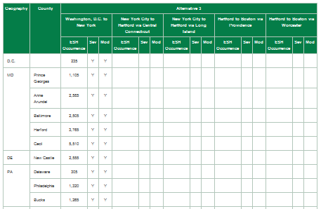
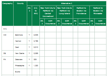
Sixteen federally managed fish species and their habitats could be affected by crossings of the Action Alternative's Representative Routes. Consistent with the Affected Environment, Connecticut contains most of the potential impacts to federally managed fish species at the state and county level. The disproportionate level of potential fish species impacts in Connecticut is in line with the Affected Environment, with the Action Alternatives' Representative Routes running proximate to or overlapping areas with many inlets and waterbodies near the Connecticut shoreline. Throughout all the Action Alternatives, Connecticut has the most federally managed fish species that would be affected, total number of EFH crossings, and linear footage of EFH crossing impact (Table 7.6-13, Table 7.6-14 and Table 7.6-15). These impacts would be concentrated primarily in Fairfield and New London Counties, CT, which contain large coastal areas that intersect with the Action Alternatives' Representative Routes. Suffolk County, NY, recorded the most acreage of EFH crossing impact, which may be attributed to the Action Alternatives crossing the Long Island Sound where EFH species are known to occur.
New Jersey is the only state where, across all Action Alternatives, all crossings within each county would have only one fish species that could be affected-the Summer Flounder (Paralichthys dentatus) (Table 7.6-13 and Table 7.6-15). Washington, D.C., Pennsylvania, and Massachusetts, have no reported crossings intersecting federally managed fish species, and therefore no possibility of fish species impact.
Of the nine states, seven (including the states with zero species) would have six or fewer possible federally managed fish species occurrences. New York and Connecticut would have the highest concentration of fish species, which may be attributed to the proximity of the Action Alternative routes to waterbodies containing fish species, including passing through the Long Island Sound and along the Connecticut coastline.
Alternative 1 ranks as the second-most total number of crossings, the second-least acreage, and the second-least linear footage of crossings.
Of the nine states, six (including the states with zero species) would have four or fewer possible fish species occurrences. New York and Connecticut would have the highest concentration of fish species, which may be attributed to the proximity of the Action Alternative routes to waterbodies containing federally managed fish species, including passing through the Long Island Sound and along the Connecticut coastline.
Alternative 2 ranks as the most crossings, and the second-most acreage and the most linear footage of crossings. The high total linear footage of EFH crossing impacts in Alternative 2 may be attributed to the higher linear footage impacts in New Jersey, New York, and Connecticut.
Of the nine states, seven would have 10 or fewer possible fish species occurrences. Crossings range from the second-fewest to the most (along with Alternative 2). Alternative 3 would have the most acreage of impacts, and the linear footage of EFH crossing impacts would increase to second-most.
Washington, D.C., to New York City
Alternative 3 from Washington, D.C., to New York City has similar EFH species per state totals as the other Action Alternatives (Table 7.6-13 ). For this section of the alignment, Alternative 3 has the most acreage and linear footage of EFH crossing impacts.
New York City to Hartford
Via Central Connecticut
From New York City to Hartford via Central Connecticut, the Representative Route is in line with the Affected Environment, where species occurrence concentration increases in New York City and Connecticut. This may be attributed in part to the Representative Route traveling the length of the Connecticut coastline, an extensive shoreline with many inlets that have higher concentrations of EFH species and protected marine mammals.
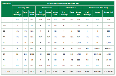
For this section of Alternative 3, EFH crossing impacts would range from 4 (New York City) to 31 (Connecticut), with ESH crossing impacts ranging from 180 acres (New York City) to 200 acres (Connecticut), and 940 linear feet (New York City) to 4,460 linear feet (Connecticut) of crossing impacts.
Via Long Island
From New York City to Hartford via Central Connecticut, the Representative Route is in line with the Affected Environment, where species occurrence concentration increases in New York and Connecticut. This may be attributed in part to the Representative Route passing through the Long Island Sound, where many of the federally managed fish species and protected marine mammal species are known to occur and migrate.
For this section of Alternative 3, New York and Connecticut recorded five EFH crossing impacts each. Acreage (2,075 acres) and linear footage (1,465 linear feet) of EFH crossing impacts were also the same for both states.
Hartford to Boston
Via Providence
Massachusetts does not have any EFH species occurrence or crossing impacts. Crossing totals range from 2 (Rhode Island) to 31 (Connecticut), and crossing impact acreage and linear footage range from 15 acres (Rhode Island) to 1,465 acres (Connecticut), and 400 linear feet (Rhode Island) to 4,460 linear feet (Connecticut). Most of the EFH species and crossing impacts would be concentrated in Connecticut because of the Representative Route's proximity to the coastline where federally managed fish species and protected marine mammals are known to occur.
Via Worcester
Massachusetts does not have any federally managed fish species occurrence or crossing impacts. Crossing totals range from 1 (Rhode Island) to 31 (Connecticut), and crossing impact acreage and linear footage ranged from 1 acre (Rhode Island) to 1,465 acres (Connecticut), and 150 linear feet (Rhode Island) to 4,460 linear feet (Connecticut). Most of the federally managed fish species and crossing impacts would be concentrated in Connecticut because of the Representative Route's proximity to the coastline where federally managed fish species and protected marine mammals are known to occur.
New station impacts to federally managed fish species would generally be minimal across the Action Alternatives. Across all the Action Alternatives, two new stations-in New Castle County, DE, and Bronx County, NY-could affect EFH by encroaching onto waterbodies containing federally managed fish species (Table 7.6-16 ). Additionally, one existing station where improvements are proposed encroaches into an EFH waterbody in New London County, CT. Table 7.6-16 identifies occurrences of only federally managed fish species and stations where effects may occur.
| State | County | Station ID/Type |
Station Name | Alternative 1 | Alternative 2 | Alternative 3 |
|---|---|---|---|---|---|---|
| DE | New Castle | 26/New | Newport | X | X | X |
| NY | Bronx | 81/New | Co-op City | X | X | X |
Source: NEC FUTURE team, 2015
Note: Quantities of potential impacts associated with stations are not shown. Acreage was calculated only for new stations and is provided in Appendix E, Section E.06.
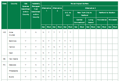
This Tier 1 Draft EIS considers locations of ESH resources, T&E species, federally managed fish species, and EFH in relation to locations of noise and vibration effects; it does not identify specific attributes of species or habitats with particular sensitivities to noise and vibration. Increased noise and vibration may create unfavorable conditions for a species to exist in those locations, resulting in a potential loss of life and habitat. Based on a review of the noise and vibration analyses undertaken for this Tier 1 Draft EIS, there would be a potential for proximity effects to ESH and T&E and EFH species and their habitats from increased noise and vibration levels. Noise impacts would occur in all Action Alternatives in all states, whereas vibration impacts would be generally less numerous and more varied in counties and states across the Action Alternatives (ranging between 3 counties/states in Alternative 1 and 26 counties in 8 states in Alternative 3). As a result, there is greater potential for noise impacts to ESH and T&E and EFH species than impacts resulting from vibration.
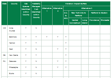
All states have known potential for total area of ESH impact, and all states within the Affected Environment would have (moderate to severe) noise and vibration affects at various locations. Noise and vibration acreage of impacts analysis for ESH resources would be similar to the total area of ESH Affected Environment and Representative Resource analysis. Connecticut would have the most noise and vibration acreages of impacts across all Action Alternatives, with the highest overall total area of ESH acreage of impact recorded in Alternative 1 (New London County). However, the quantity of vibration impacts would vary per state and county across the Action Alternatives, with Alternative 1 having the lowest occurrence (and therefore lowest potential for impacts) of total area of ESH impact and Alternative 2 having the highest occurrence of total area of ESH vibration impacts. able 7.6-17 and Table 7.6-18 summarizes areas of ESH that coincide with identified noise and vibration impacts, respectively.
All states and Washington, D.C., within the Affected Environment would have moderate to severe noise impacts. All states (except Washington, D.C.) also have known T&E species occurrences. As a result, all states have the potential for noise impacts to intersect with T&E species. From Washington, D.C., to Westchester, NY, potential noise impacts to T&E species would be the same for all the Action Alternatives. From New York to Massachusetts, Alternatives 1 and 2 would have similar noise impacts to T&E species from state to state (Alternative 2 would have slightly more impacts), and Alternative 3 would have higher overall numbers of potential noise impacts to T&E species from state to state. The only counties with no T&E species that would have no potential for noise impacts include Washington, D.C.; Prince George's County, MD; Essex County, NJ; Tolland County, CT; and Worcester, Middlesex, and Norfolk Counties, MA. Where there is potential for T&E species impacts, potential impacts range from 1 (multiple counties and states) to 14 species (Suffolk, NY). Table 7.6-19 and Table 7.6-20 summarize occurrences of T&E species with identified noise and vibration effects, respectively, by state and county. A complete listing of species and habitat occurrences with noise and vibration effects is in Appendix E, Section E.06.
The quantity of vibration impacts would vary per state across the Action Alternatives with Alternative 1 having the fewest and Alternative 3 having the most. As a result, by state, Alternative 1 would have the lowest potential for vibration impacts to T&E species, Alternative 2 would have mid-range potential, and Alternative 3 would have the greatest potential for vibration impacts to T&E species. In general, only the eight states (except Washington, D.C.) within the Study Area could have vibration impacts and have known T&E species occurrences. Similar to noise impacts, only the eight states could have vibration impacts that intersect with T&E species. The only counties with no T&E species that would have no potential for vibration impacts include Bucks, PA; Mercer, Union, and Essex, NJ; Tolland, CT; and Worcester and Norfolk, MA. Where there is potential for vibration impacts to T&E species, potential impacts range from 1 (multiple counties and states) to 14 species (Suffolk, NY).
Table 7.6-17: Ecologically Sensitive Habitat Acreage with Noise Effects
Table 7.6-18: Ecologically Sensitive Habitat Acreage with Vibration Effects
Table 7.6-19: Threatened and Endangered and Federally Managed Fish Species Occurrences with Noise Effects
Table 7.6-20: Threatened and Endangered and Federally Managed Fish Species Occurrences with Vibration Effects
Washington, D.C., Pennsylvania, and Massachusetts have no federally managed fish species and therefore no potential for noise impacts to these fish species. The six remaining states within the Study Area could have moderate to severe noise impacts to fish species occurrences. From Washington, D.C., to Westchester, NY, potential noise impacts to fish species would be the same across the Action Alternatives. From New York to Massachusetts, Alternatives 1 and 2 would have similar impacts from state to state (Alternative 2 would have slightly more impacts), and Alternative 3 would have higher overall numbers of potential federally managed fish species noise impacts from state to state. The only counties with no fish species that would have no potential for noise impacts include Prince George's and Anne Arundel Counties, MD; Mercer and Union Counties, NJ; Westchester and Nassau Counties, NY; Tolland and Windham Counties, CT; and Washington, RI. Where there is potential for federally managed fish species impacts, potential impacts range from 1 (multiple counties and states) to 15 fish species (Fairfield and New London Counties, CT).
There is variation in the quantity of vibration impacts per state across the Action Alternatives with Alternative 1 having the fewest and Alternative 3 having the most. As a result, by state, Alternative 1 would have the lowest potential for vibration impacts to federally managed fish species, Alternative 2 would have mid-range potential, and Alternative 3 would have the greatest potential for vibration impacts to fish species. Washington, D.C., Pennsylvania, and Massachusetts have no fish species and therefore no potential for vibration impacts. The remaining six states within the Study Area could have vibration impacts and federally managed fish species occurrences. Only the following counties with no fish species have no potential for vibration impacts: Prince George's, Anne Arundel, and Cecil Counties, MD; Mercer, Union, and Essex Counties, NJ; Kings, Putnam, and Nassau Counties, NY; Tolland and Windham Counties, CT; and Washington, RI. Where there is potential for vibration impacts to federally managed fish species, potential impacts range from 1 (multiple counties and states) to 15 fish species (Fairfield, CT).
The distribution and quantity of ecological resources within the Context Area are similar to the Affected Environment for ESH, T&E species, and EFH species.
The Context Area is inclusive of the Affected Environment, and as a result, any T&E or federally managed fish species listed in the Affected Environment would also occur in the Context Area. The Maryland Darter (Etheostoma sellare) in Harford County, MD, was identified as the only T&E species with critical habitat to occur in the Context Area as well as the Affect Environment. The area (linear feet) of overlap between the Context Area and species' critical habitat was calculated and recorded for the Context Area (refer to Appendix E, Section E.06).
Three T&E species are known to occur only within the Context Area for the Action Alternatives. These species include the Hay's Spring Amphipod (Stygobromus hayi), an endemic endangered arthropod occurring in springs along Rock Creek in Washington, D.C.; the Sensitive Joint-Vetch (Aeschynomene virginica), a threatened plant known to occur within the Context Area in Maryland and New Jersey; and the Knieskern's Beaked-Rush (Rhynchospora knieskernii) an endemic threatened plant species known to occur within the Context Area in New Jersey.
Three federally managed fish species are known to occur only within the Context Area for the Action Alternatives. These species include the Monkfish (Lophius americanus) and Clearnose Skate (Raja eglanteria), which are known to occur within the Context Area only in Queens County, NY (Jamaica Bay); and the Atlantic Halibut (Hippoglossus hippoglossus), which is known to occur within the Context Area only in Suffolk County, MA (Boston Harbor).
These T&E and federally managed fish species and associated habitats will not be investigated further since they are not known to occur within the Affected Environment, and are considered species requiring no further evaluation. If an Action Alternative alignment shift were to occur, these species would be reevaluated to determine if they fall within the Affected Environment and are species of concern.
Potential mitigation strategies should include restricting ESH area disturbance to the perimeter of the habitat area, minimizing habitat fragmentation, implementing a forest conservation/ management plan, implementing best management practices with regard to wildlife crossings, native vegetation stabilization, and tree replacement. Furthermore, where and when feasible, mitigation strategies should also consider removal of obsolete impervious surfaces from riparian and shoreline areas and the improvement of ESH areas outside the Study Area, including wetlands and forested land.
Potential mitigation strategies should include continued coordination with the USFWS for specific mitigation measures for any affected T&E species, adherence to habitat conservation plans and permitting requirements, restricting disturbance of T&E habitat, and implementation of best management practices and invasive species control. Program-wide or habitat-specific mitigation strategies could be developed with the agencies, as appropriate, through the permit process.
Potential mitigation strategies should include establishing monitoring and adaptive management practices for affected federally managed fish species, establishing a stocking program, improving EFH areas not related to the Study Area, and treating elevated levels of chemicals, metals, and other contaminants in the waterbodies near the Study Area.
Tier 2 assessments would refine the impact assessment based on design and site-specific mapping. In addition to analyzing potential impacts to protected resources for the Tier 2 assessment, an analysis of impacts to common ecological resources would be required if impacts are anticipated. Mitigation measures to offset these site-specific impacts would be developed.
The information acquired from the evaluation of ESH areas in this Tier 1 Draft EIS would inform and direct analysis needed during Tier 2 studies. Subsequent analysis, including field surveys for ESH areas would be necessary to identify the most sensitive ESH areas.
The information acquired from the evaluation of T&E species analysis in this Tier 1 Draft EIS would inform and direct analysis needed during Tier 2 studies. Subsequent analysis, including field surveys for "species/areas of concern" would be necessary to identify sensitive T&E habitat areas and potential impacts to T&E species. Biological assessments should be conducted to determine whether suitable habitat is present for listed species.
Consultation with USFWS under Section 7 of the federal ESA and with the NMFS under Section 7 and under Section 305(b) of the Magnuson-Stevens Fishery Conservation and Management Act for potential impacts to EFH is ongoing and would continue to be required. The FRA hosted presentations with the NMFS (August 4, 2014) and the USFWS (January 7, 2015), providing an overview of NEC FUTURE and information regarding the Ecological Resources effects assessment. The presentation also provided a platform for discussing Section 7 consultation and NOAA/NMFS and USFWS expectations for continued agency coordination. It was determined that no formal Section 7 consultation would occur at the Tier 1 EIS analysis. (See Appendix E, Section E.06, for the email correspondence, March 20, 2015.)
The FRA submitted a list of species and critical habitats identified for inclusion in the Tier 1 Draft EIS to NOAA/NMFS and USFWS: November 3, 2014 (for NOAA/NMFS feedback) and January 13, 2015 (for USFWS feedback). NOAA/NMFS provided feedback December 19, 2014, and four USFWS field offices have provided feedback: Pennsylvania (February 9, 2015), New York (March 2015), New England (April 4, 2015), and Chesapeake Bay (May 14, 2015). The FRA reviewed and incorporated the correspondence into this Tier 1 Draft EIS.
Formal consultation by the FRA or other federal action agency with the USFWS and NMFS would be considered at the Tier 2 environmental compliance process if the Tier 2 project's impacts are "likely to adversely affect" a federally protected species. In most instances, any activity that proposes disturbance or "take" of a protected species or habitat is prohibited by the laws and regulations. When formal consultation occurs, the USFWS or NMFS must prepare a Biological Opinion, stating whether the project would put the continued existence of any listed species or EFH in jeopardy. If jeopardy is considered likely and unavoidable, the project must be subsequently exempted or it cannot proceed. If jeopardy is not considered likely or if it is avoidable, then the USFWS or NMFS would issue an Incidental Take Statement, with any conditions of approval or mitigation measures, and the project may commence.
The information derived from the evaluation of EFH in this Tier 1 Draft EIS would inform and direct the analysis needed during Tier 2 studies. The Tier 1 EIS and Record of Decision will identify any areas and fish species of concern that may require subsequent analysis. Formal consultation with the NMFS would then be undertaken if the federal agency undertaking the action identifies the possibility of affecting federally protected EFHs.
The Magnuson-Stevens Fishery Conservation and Management Act (MSFCMA) requires the federal agency to consult with the Secretary of Commerce with respect to any action authorized, funded, or undertaken or proposed to be authorized, funded, or undertaken, by such agency that may adversely affect any EFH identified under the Act (refer to previous section for more information). If an adverse effect may occur to EFH and federally managed fish species protected under the MSFCMA, a written EFH Assessment should be prepared describing the effects of the project on EFH and fish species, and identifying proposed mitigation measures. The NMFS will then provide EFH Conservation Recommendations to avoid and/or minimize adverse effects to EFH and fish species inhabiting these EFHs.
The information posted on this website includes hypertext links or pointers to information created and maintained by other public and/or private organizations. The FRA provides these links and pointers solely for information and convenience. When users select a link to an outside website, they are leaving the NEC FUTURE website and are subject to the privacy and security policies of the owners/sponsors of the outside website. The FRA does not control or guarantee the accuracy, relevance, timeliness or completeness of information contained on a linked website, or endorse the organizations sponsoring linked websites, the views they express, or the products/services they offer. The FRA cannot authorize the use of copyrighted materials contained in linked websites and is not responsible for transmissions users receive from linked websites.