Key Resource: Section 4(f) Resources
This chapter provides a preliminary assessment of potential resources protected under Section 4(f) of the Department of Transportation Act of 1966 (Section 4(f)) that could be affected by the Tier 1 Draft Environmental Impact Statement (Tier 1 Draft EIS) Action Alternatives. Once the Federal Railroad Administration (FRA) identifies a Preferred Alternative, the Tier 1 Final EIS will address whether additional Section 4(f) evaluation is appropriate at Tier 2. The inclusion of a Section 4(f) resource in this Tier 1 assessment does not necessarily mean that resource will be used.
This Tier 1 Draft EIS identifies the Section 4(f) resources that could be used under Section 4(f) based on an analysis utilizing Representative Routes and representative service information. As described in Section 7.16.1.8, the information contained in this analysis will be used as input during Tier 2 evaluations, including in the evaluation of possible avoidance alternatives. The FRA will not make a Section 4(f) determination as part of this Tier 1 EIS process. Such determinations will be made as part of the Tier 2 environmental compliance process, when more-detailed and specific information is available regarding the project location and design (i.e., location of alignments, duration and extent of construction, specific construction methods, and staging areas) and information regarding the location, boundaries, and significance of Section 4(f) resources are known.
Section 4(f) was enacted as a means of protecting the following resources from conversion to transportation uses: publicly owned parks, recreation areas, and wildlife/waterfowl refuges, as well as historic sites of local, state, or national significance (eligible or listed). Historic properties also include artifacts, records, and material remains that are related to and located within such properties, and properties of religious and cultural importance to an Indian Tribe or Native Hawaiian organization, and that meet the National Register criteria. Traditional cultural properties may also be protected under Section 4(f) if they are on or eligible for listing on the National Register of Historic Places. The FRA has included tribal resources identified as part of the National Park Service (NPS) 2010 database, the Housing and Urban Development (HUD) Tribal Directory Assessment Tool (TDAT) database, and correspondence with identified tribes (see Chapter 7.9, Cultural Resources and Historic Properties, and Appendix G) in this assessment.
Under Section 4(f), a use occurs under the following conditions:
The issue of compliance with Section 4(f) in a tiered National Environmental Policy Act (NEPA) process is not specifically addressed in the FRA's environmental procedures, but is addressed in the FHWA/FTA Section 4(f) Policy Paper (2012) and Section 4(f) regulations 23 CFR Part 774), where it states, "[w]hen the first-tier, broad-scale EIS is prepared, the detailed information necessary to complete the Section 4(f) approval may not be available at that stage in the development of the action. In such cases, the documentation should address the potential impacts on the Section 4(f) property and whether those impacts could have a bearing on the decision to be made. The Section 4(f) approval will be finalized in the second-tier study."1
The FRA used the analyses conducted for parklands, recreational areas, and wildlife and waterfowl refuges, and historic resources as the basis for the Section 4(f) evaluation. Table 7.16-1 summarizes key factors associated with the effects-assessment methodologies for each category of Section 4(f) resources evaluated as part of this Tier 1 Draft EIS.
Appendix H, Preliminary Section 4(f) and Section 6(f) Evaluations, provides the methodology for evaluating Section 4(f) resources and includes the supporting data that the FRA used in its analysis. Appendix A, Mapping Atlas, provides the general locations of Section 4(f) Resources in relationship to each of the Action Alternatives.
| Resource | Affected Environment | Type of Assessment | Outcomes |
|---|---|---|---|
| Section 4(f) - Parklands | 2,000-foot-wide swath centered along Representative Route for each Action Alternative | Quantitative: Acres | Identification of potential crossing of a resource that may result in a potential use of parklands by the Action Alternatives; qualitative assessment of constructive use introduced by proximity effects |
| Section 4(f) - Historic Resources* | 1-mile-wide swath centered along Representative Route for each Action Alternative | Quantitative: Number of NRHP and NHL sites identified in NPS 2010 data base Tribal counties of interest identified through coordination with tribes and HUD TDAT data** | Identification of potential effects on historic resources (those listed on the National Register of Historic Places) by the Action Alternatives that may result in a use; qualitative assessment of constructive use introduced by proximity effects |
Sources: NEC FUTURE Section 4(f) Effects-Assessment Methodologies, Appendix H, 2014.
* Historic resources eligible for (but not yet included in) National Register of Historic Places listing are not included in the Section 4(f) analysis.
** Tribal coordination and efforts to identify tribal resources are documented in Appendix G, Section 106 Documentation
Implementation of the No Action or Action Alternatives could result in a use of Section 4(f) resources through modifications to existing rail infrastructure or construction of new rail infrastructure through Section 4(f) properties. For purposes of this Tier 1 Draft EIS, a use of a Section 4(f) property could result from a Representative Route crossing2 the resource. Implementation of the No Action or Action Alternatives could also result in proximity effects to Section 4(f) properties, such as noise and vibration effects caused by new service on new routes or changes in service on existing routes.
This Section 4(f) analysis focuses on the environmental effects identified in Chapter 7.4, Parklands and Wild and Scenic Rivers, and Chapter 7.9, Cultural Resources and Historic Properties.
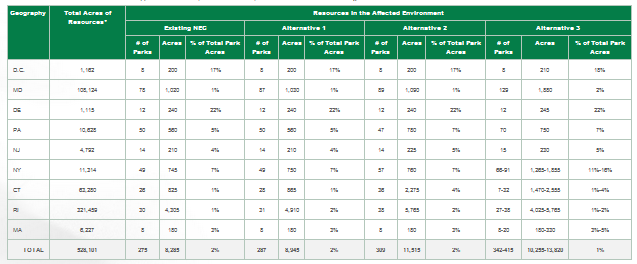
Parklands, recreational areas, and wildlife and waterfowl refuges are scattered throughout the 2,000-foot-wide Affected Environment. Maryland, New York, Connecticut, Rhode Island, and Massachusetts have the largest parks in the Affected Environment, while higher acreages of parklands are located in areas where the Action Alternatives diverge from the existing NEC and create new segments or extend off-corridor, primarily in New York under Alternative 3, and Connecticut and Rhode Island under all the Action Alternatives. The most individual parks exist in Maryland, Pennsylvania, New York, Connecticut, and Rhode Island.
Key findings for the analysis of the Action Alternatives' effects on parklands that are Section 4(f) properties are listed below:
Depending on identification of the Preferred Alternative, subsequent project phases would further examine the relevant parks listed above to avoid or minimize impacts.
Implementation of the No Action and Action Alternatives could affect cultural resources and historic properties through physical disturbance or demolition of the resource, through proximity effects such as noise and vibration, or through proposed changes to the visual character or aesthetic qualities. The FRA identified numerous historic properties listed on the NRHP, some of which are designated as NHLs within the Study Area. NHLs are specifically called out in this analysis because of their national importance and because they require the most stringent consultation under Section 106 of the National Historic Preservation Act (NHPA) to resolve adverse effects. Potential effects on NHLs are an important consideration in identifying a Preferred Alternative.
Cultural resources and historic properties are dispersed throughout the Study Area with higher numbers of NRHP properties and especially NHLs found in urban areas that were heavily populated during the colonial era (i.e., Washington, D.C., Philadelphia, New York City, Providence, and Boston). Typically, greater numbers of historic buildings and districts are associated with areas where the Action Alternatives are close to the existing NEC, or divert into new urban areas.
In addition, the FRA identified federally recognized tribes known to have tribal lands or resources, or that claim ancestral lands or resources, in counties within the Study Area. The FRA further identified those federally recognized tribes that claim ancestral lands or resources in counties traversed by the No Action and Action Alternatives. Tribal and ancestral lands have been identified in Suffolk County, NY; New London County, CT; and Washington County, RI. Additional ancestral lands have been identified in all counties within the Study Area that are located in Pennsylvania, New Jersey, New York, Connecticut, Rhode Island, and Massachusetts.
Key findings of this analysis are:
Table 7.16-2 presents a summary of the parks, recreational areas, and wildlife and waterfowl refuges in the Affected Environment. For each of the Action Alternatives, Table 7.16-2 identifies the number of federal, state, and/or county parks, total park acreage, and percentage of the total park acreage within the Affected Environment. Table 7.16-3 presents a summary of the historic resources (i.e., both NHLs and NRHP sites) in the Affected Environment. (See Chapter 7.4, Parklands and Wild and Scenic Rivers, for a detailed description of the parks, recreational areas, and wildlife and waterfowl refuges. See Chapter 7.9, Cultural Resources and Historic Properties, for a description of the cultural resources.) Appendix E, Section E.16, provides all data for each state and county. Appendix A, Mapping Atlas, depicts resources by county.
This section provides a broad overview of how the Action Alternatives would affect Section 4(f) resources and identifies areas where a potential use would occur.
For purposes of this analysis, an environmental effect was noted for those parks, recreational areas, wildlife and waterfowl refuges, and historic resources that lie within the Representative Route of each Action Alternative. Resources identified within the Representative Route have a higher likelihood of being directly affected by an Action Alternative, resulting in a Section 4(f) use.
See Chapter 7.4, Parklands and Wild and Scenic Rivers, and Chapter 7.8, Cultural Resources and Historic Properties, for more information.
Table 7.16-2 : Affected Environment: Section 4(f) Resources - Parks,
Recreational Areas, and Wildlife and Waterfowl Refuges
| Geography | Resource Type | Existing NEC (# of sites) |
Alternative 1 (# of sites) |
Alternative 2 (# of sites) |
Alternative 3* (# of sites) |
|---|---|---|---|---|---|
| D.C. | NHL | 10 | 10 | 10 | 10 |
| NRHP-Listed | 21 | 30 | 30 | 29 | |
| MD | NHL | 3 | 3 | 3 | 15 |
| NRHP-Listed | 66 | 96 | 96 | 230 | |
| DE | NHL | 3 | 3 | 3 | 2 |
| NRHP-Listed | 64 | 83 | 84 | 84 | |
| PA | NHL | 12 | 10 | 10 | 27 |
| NRHP-Listed | 97 | 138 | 135 | 305 | |
| NJ | NHL | 4 | 4 | 4 | 4 |
| NRHP-Listed | 64 | 86 | 86 | 89 | |
| NY | NHL | 10 | 11 | 11 | 12-20 |
| NRHP-Listed | 80 | 102 | 106 | 131-200 | |
| CT | NHL | 12 | 13 | 15 | 14-15 |
| NRHP-Listed | 199 | 218 | 312 | 322-373 | |
| RI | NHL | 6 | 6 | 8 | 6-8 |
| NRHP-Listed | 135 | 158 | 191 | 156-191 | |
| MA | NHL | 11 | 11 | 11 | 10-11 |
| NRHP-Listed | 101 | 125 | 125 | 129-405 | |
| Alternative Total - NHL | 71 | 71 | 75 | 100-112 | |
| Alternative Total - NRHP-Listed | 829 | 1,036 | 1,165 | 1,510-1,870 | |
Source: NEC FUTURE team, 2015
Note: All Action Alternatives assume improvements to the existing NEC; therefore, the number of resources presented is inclusive of the existing NEC as well as any new option or off-corridor route associated with each Action Alternative. Counts of National Register of Historic Places-listed sites and National Historic Landmarks include both individual sites and districts. Only tribal resources identified as part of the National Park Service (NPS) 2010 database have been included in the table. Numbers have not been rounded since they are discrete occurrences identified by the NPS. Historic resources eligible for NRHP listing are not included in the Section 4(f) analysis.
*The ranges represent the different alternative route options considered as part of Alternative 3.
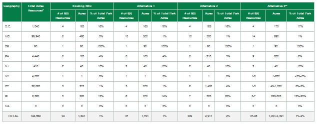
Table 7.16-4 summarizes the number of parks, recreational areas, and wildlife and waterfowl refuges that could potentially be affected under each Action Alternative. Table 7.16-5 provides the number of resources that could potentially be affected for each Alternative 3 route option. (See Chapter 7.4, Parklands and Wild and Scenic Rivers, for a detailed description of the parks, recreational areas, and wildlife and waterfowl refuges. Appendix H provides all data for each state and county. Appendix A, Mapping Atlas, depicts resources by county.)
While many parks within the Affected Environment are adjacent to the existing NEC and experience effects such as visual interference and noise, all or portions of parks that are within the footprint of areas where new infrastructure is proposed could be converted to a non-park use and, therefore, would experience greater effects.
In addition, parks adjacent to new infrastructure may also experience proximity effects, such as new noise and vibration impacts, from an increase in trains passing and visual impacts resulting from new construction and operation of the proposed service. Proximity effects have the potential to prevent a resource from being used in accordance with its intended purpose. For example, a park intended to be used for meditative purposes could no longer be useable if a proposed action introduces a proximity effect, such as new noise.
Proximity effects could also result in a constructive use. Constructive use may include impacts such as noise, access restrictions, vibration, ecological intrusions, and visual impacts. For example, a constructive use would occur if increased noise levels substantially interfere with the use of a noise sensitive feature such as a campground or outdoor amphitheater. It should be noted, though, that the determination of a constructive use of Section 4(f) land is rare.
More specifically, the following general effects on parklands could occur as a result of the various construction types and methods proposed:
| Geography | Existing NEC | Alternative 1 | Alternative 2 | Alternative 31 | ||||
|---|---|---|---|---|---|---|---|---|
| # of Parks | Acres within the Alignment | # of Parks2 | Acres within the Rep. Rte. 2 | # of Parks2 | Acres within the Rep. Rte. 2 | # of Parks2 | Acres within the Rep. Rte. 2 | |
| D.C. | 3 | 10 | 3 | 10 | 3 | 10 | 4 | 25 |
| MD | 15 | 10 | 15 | 10 | 17 | 25 | 24 | 190 |
| DE | 5 | 5 | 5 | 5 | 5 | 5 | 6 | 15 |
| PA | 17 | 20 | 17 | 20 | 18 | 45 | 19 | 50 |
| NJ | 5 | 2 | 5 | 2 | 6 | 10 | 6 | 15 |
| NY | 9 | 50 | 9 | 50 | 9 | 50 | 13-16 | 115-125 |
| CT | 17 | 50 | 18 | 55 | 23 | 105 | 21-23 | 60-90 |
| RI | 19 | 265 | 20 | 350 | 25 | 345 | 18-25 | 265-350 |
| MA | 5 | 25 | 5 | 25 | 5 | 25 | 5-7 | 25-45 |
| TOTAL | 95 | 435 | 97 | 525 | 111 | 620 | 116-130 | 760-905 |
Source: NEC FUTURE team, 2015
1 The range represents the Representative Route design options for Alternative 3.
2 All Action Alternatives assume improvements to the existing NEC; therefore, the number of resources presented is inclusive of the existing NEC as well as any new option or off-corridor route associated with each Action Alternative.
Note: While the totals for each alternative include parks that are along the existing NEC, some parks would have additional effects under the alternative. For instance, West Park is located along the existing NEC, but it would have additional impacts under Alternative 1 because of the proposed bridge. There is one wild and scenic river-White Clay Creek in New Castle, Delaware-which is crossed by the existing NEC and all Action Alternatives. Alternative 3 creates a new crossing. White Clay Creek qualifies for protection under Section 4(f) since the management plan for White Clay Creek addresses recreation and other Section 4(f) uses.
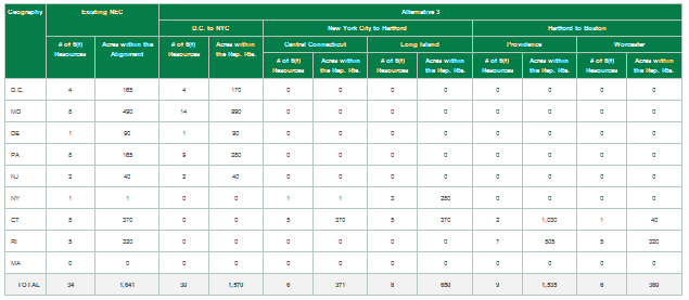
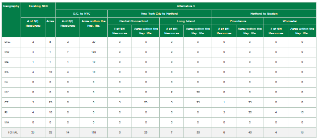
| Geography | D.C. to NYC | New York City to Hartford | Hartford to Boston | |||||||
|---|---|---|---|---|---|---|---|---|---|---|
| # of Parks | Acres | via Central Connecticut | via Long Island | via Providence | via Worcester | |||||
| # of Parks | Acres | # of Parks | Acres | # of Parks | Acres | # of Parks | Acres | |||
| D.C. | 4 | 25 | - | - | - | - | - | - | - | - |
| MD | 24 | 190 | - | - | - | - | - | - | - | - |
| DE | 6 | 15 | - | - | - | - | - | - | - | - |
| PA | 19 | 50 | - | - | - | - | - | - | - | - |
| NJ | 6 | 15 | - | - | - | - | - | - | - | - |
| NY | - | - | 13 | 120 | 16 | 130 | - | - | - | - |
| CT | - | - | 20 | 55 | 18 | 50 | 3 | 40 | 3 | 15 |
| RI | - | - | - | - | - | - | 25 | 350 | 18 | 265 |
| MA | - | - | - | - | - | - | 5 | 40 | 7 | 30 |
| TOTAL | 59 | 300 | 33 | 175 | 34 | 180 | 33 | 430 | 28 | 310 |
Source: NEC FUTURE team, 2015
Note: All Action Alternatives assume improvements to the existing NEC; therefore, the number of resources presented is inclusive of the existing NEC as well as any new option or off-corridor route associated with each Action Alternative.
- = Not applicable within that alternative/route option.
Temporary construction effects could occur where access roads are created and at staging and lay-down areas. Impacts could include temporary disturbance to existing parklands. Chapter 8, Construction Effects, presents a qualitative description and examples of potential construction-related effects for parklands.
Stations
Table 7.16-6 summarizes the potential Environmental Consequences of the proposed stations to Section 4(f) parklands, recreational areas, and wildlife and waterfowl refuges. The effects described in Table 7.16-6 would be the same for all alternatives. Permanent infrastructure and/or operations at these stations associated with the Action Alternatives have the potential to result in a permanent use to all resources listed.
| State | County | Station ID/Type | Station Name | Potential Effects for All Representative Routes |
|---|---|---|---|---|
| MD | Baltimore City | 9/New | Upton | 4 parks would be acquired
|
| 12/New | Broadway | 2 parks would be acquired
|
||
| PA | Delaware | 34/New | Baldwin | Potential partial acquisition of Bicycle Route/PA; potential noise and visual effects |
| NY | Bronx | 81/New | Co-op City | Potential partial acquisition of Pelham Bay Park; potential noise and visual effects |
| RI | Providence | 129/New | Providence Station H.S. | Potential partial acquisition of and visual and noise effects to:
|
Source: NEC FUTURE team, 2015
Note: Quantities of potential impacts associated with stations are not shown. Acreage has been calculated only for new stations and is provided in Appendix E, Section E.16.
H.S. = high speed
Table 7.16-7 presents the historic resources identified within the Representative Route of each Action Alternative, all of which could result in a use. Table 7.16-8 provides the number of resources for each Alternative 3 route option. Appendix E, Section E.09, contains the number of historic resources by county, provides qualitative highlights of the historic resources by county, and qualitative highlights of the potential Environmental Consequences for each county. (See Chapter 7.9, Cultural Resources and Historic Properties, for a detailed discussion of the potential effects to historic resources.)
| Geography | Resource Type | Existing NEC (# of sites) |
Alternative 1 (# of sites) |
Alternative 2 (# of sites) |
Alternative 3* (# of sites) |
|---|---|---|---|---|---|
| D.C. | NHL | 0 | 1 | 1 | 1 |
| NRHP-Listed | 3 | 7 | 7 | 7 | |
| MD | NHL | 0 | 0 | 0 | 0 |
| NRHP-Listed | 1 | 13 | 13 | 17 | |
| DE | NHL | 0 | 0 | 0 | 0 |
| NRHP-Listed | 2 | 9 | 9 | 7 | |
| PA | NHL | 0 | 3 | 4 | 5 |
| NRHP-Listed | 2 | 5 | 5 | 8 | |
| NJ | NHL | 0 | 0 | 0 | 0 |
| NRHP-Listed | 3 | 12 | 13 | 12 | |
| NY | NHL | 0 | 0 | 0 | 0 |
| NRHP-Listed | 1 | 12 | 12 | 13-19 | |
| CT | NHL | 0 | 0 | 0 | 0 |
| NRHP-Listed | 16 | 47 | 65 | 45-51 | |
| RI | NHL | 0 | 1 | 1 | 1 |
| NRHP-Listed | 1 | 24 | 33 | 3-21 | |
| MA | NHL | 0 | 0 | 0 | 0-1 |
| NRHP-Listed | 3 | 13 | 14 | 16-17 | |
| Alternative Total - NHL | 0 | 4 | 5 | 5-7 | |
| Alternative Total - NRHP-Listed | 32 | 142 | 171 | 132-150 | |
Source: NEC FUTURE team, 2014
Note: All Action Alternatives assume improvements to the existing NEC; therefore, the number of resources presented includes the Environmental Consequences inclusive of improvements to existing NEC and any new segment or off-corridor route associated with each Alternative. Counts of NRHP-listed sites and NHLs include both individual sites and districts with multiple structures that are counted as one individual site.
NHL: National Historic Landmark; NRHP: National Register of Historic Places
* The range represents the Representative Route design options for Alternative 3. See the Alternative 3 discussion below.
| Geography | Resource Type | Existing NEC | Alternative 3 | ||||
|---|---|---|---|---|---|---|---|
| D.C. to NYC (# of sites) | New York City to Hartford | Hartford to Boston | |||||
| via Central Connecticut (# of sites) | via Long Island (# of sites) | via Providence (# of sites) | via Worcester (# of sites) | ||||
| D.C. | NHL | 0 | 0 | - | - | - | - |
| NRHP-Listed | 3 | 7 | - | - | - | - | |
| MD | NHL | 0 | 0 | - | - | - | - |
| NRHP-Listed | 1 | 15-17 | - | - | - | - | |
| DE | NHL | 0 | 0 | - | - | - | - |
| NRHP-Listed | 2 | 4-7 | - | - | - | - | |
| PA | NHL | 0 | 5 | - | - | - | - |
| NRHP-Listed | 2 | 8 | - | - | - | - | |
| NJ | NHL | 0 | 0 | - | - | - | - |
| NRHP-Listed | 3 | 12 | - | - | - | - | |
| NY | NHL | 0 | - | 0 | 0 | - | - |
| NRHP-Listed | 1 | - | 13 | 19 | - | - | |
| CT | NHL | 0 | - | 0 | 0 | 0 | 0 |
| NRHP-Listed | 16 | - | 25 | 21 | 6 | 3 | |
| RI | NHL | 0 | - | - | - | 1 | 1 |
| NRHP-Listed | 1 | - | - | - | 21 | 30 | |
| MA | NHL | 0 | - | - | - | 0 | 1 |
| NRHP-Listed | 3 | - | - | - | 16 | 17 | |
| TOTAL NHL | 0 | 5 | 0 | 0 | 1 | 2 | |
| TOTAL NRHP-Listed | 32 | 46-51 | 36 | 40 | 43 | 50 | |
Source: NEC FUTURE team, 2015
Note: All Action Alternatives assume improvements to the existing NEC; therefore, the number of resources presented includes the Environmental Consequences inclusive of improvements to the existing NEC and any new segment or off-corridor route associated with each Action Alternative. Totals for Alternative 3 do not equal the totals presented in Table 7.16-7. This is a result of the way Alternative 3 diverges in Hartford, CT, and data were assigned to a specific route option in a conservative manner (i.e., if a resource fell within the Representative Route of multiple Alternative 3 route options, it was counted as an effect under each Alternative 3 route option).
- = Not applicable within that alternative/route option.
A summary of the potential effects to Section 4(f) resources by construction type is provided below:
Temporary construction effects could occur where temporary access roads are built, and at staging and lay-down areas. Impacts could include temporary contextual disturbance to existing NHLs and NRHP-listed resources, and direct physical disturbance to below-grade NHLs and NRHP-listed resources through grading, earth moving, compaction, and/or landscaping.
Stations
The Action Alternatives include continued service to existing stations along the NEC, modifications to existing stations, which may require an increase in the station footprint, and new stations. Based on a review of resources included on the NRHP, many of the existing stations along the NEC are NRHP-listed; however, the eligibility of the existing stations was not considered in this analysis.
Adverse effects may occur at existing NRHP-listed or NHL stations where modifications are proposed, or to adjacent NRHP-listed or NHL sites, for example, if an increase in station footprint is proposed. Major effects may also occur at new stations that affect NRHP-listed or NHL sites. Table 7.16-9 identifies effects by alternative that could be caused by modified or new stations (each identified by station ID). (Appendix E, Section E.9, provides detailed support data for Table 7.16-9. Those resources that may be eligible for listing on the NRHP were not included in this assessment.)
| Geography | County | Station ID | Station Type | Station Name | Alt. 1 | Alt. 2 | Alt. 3 |
|---|---|---|---|---|---|---|---|
| D.C. | 1 | Existing | Washington Union | X | X | X | |
| MD | Prince George's | 4 | Existing | Bowie State | X | X | X |
| Baltimore City | 9 | New | Upton | X | X | X | |
| 10 | Existing | Baltimore Penn Station | X | X | X | ||
| 11 | New | Baltimore Downtown | X | ||||
| 12 | Broadway | X | X | X | |||
| Cecil | 23 | Elkton | X | X | X | ||
| DE | New Castle | 25 | Existing | Churchman's Crossing | X | X | X |
| 26 | New | Newport | X | X | X | ||
| 27 | Existing | Wilmington Station | X | X | X | ||
| 28 | New | Edgemoor | X | X | X | ||
| 29 | Existing | Claymont | X | X | X | ||
| PA | Delaware | 32 | Existing | Chester | X | X | X |
| Philadelphia | 45 | Philadelphia 30th Street | X | X | X | ||
| 46 | Philadelphia Market East | X | |||||
| 47 | North Philadelphia | X | X | X | |||
| Bucks | 53 | Cornwells Heights | X | X | X | ||
| 57 | Levittown | X | X | X | |||
| NJ | Middlesex | 64 | Existing | New Brunswick | X | X | X |
| Union | 71 | Elizabeth | X | X | X | ||
| Essex | 74 | Newark Penn Station | X | X | X | ||
| 75 | Newark Penn Station H.S. | X | |||||
| NY | New York | 77 | Existing | Penn Station New York | X | X | X |
| New York | 9993 | Grand Central Terminal | X | ||||
| Westchester | 82 | Existing | New Rochelle | X | X | X | |
| 88 | Port Chester | X | X | X | |||
| CT | Fairfield | 89 | Existing | Greenwich | X | X | X |
| 90 | Cos Cob | X | X | X | |||
| 91 | Riverside | X | X | X | |||
| 92 | Old Greenwich | X | X | X | |||
| 93 | Stamford | X | X | X | |||
| 94 | New | Stamford H.S. | X | ||||
| 95 | Existing | Noroton Heights | X | X | X | ||
| 96 | Darien | X | X | X | |||
| 98 | South Norwalk | X | X | X | |||
| 100 | Westport | X | X | X | |||
| 102 | Greens Farms | X | X | X | |||
| 103 | Fairfield | X | X | X | |||
| 104 | Fairfield Metro | X | X | X | |||
| 105 | Bridgeport | X | X | X | |||
| 108 | Stratford | X | X | X | |||
| New Haven | 109 | Existing | Milford | X | X | X | |
| 111 | New Haven Station | X | X | X | |||
| 112 | New | New Haven Station H.S. | X | X | |||
| 113 | Existing | New Haven State Street | X | X | X | ||
| 114 | Branford | X | X | X | |||
| 115 | Guilford | X | X | X | |||
| New London | 121 | Existing | New London | X | X | X | |
| 122 | Mystic | X | X | X | |||
| 124 | New | Mystic/New London H.S. | X | ||||
| Hartford | 161 | New | Newington | X | |||
| 164 | Hartford (New) | X | X | ||||
| 166 | Tolland/Storrs | X | |||||
| RI | Washington | 123 | Existing | Westerly | X | X | X |
| 125 | Kingston | X | X | X | |||
| 126 | Wickford Junction | X | X | X | |||
| Providence | 128 | Existing | Providence Station | X | X | X | |
| 129 | New | Providence Station H.S. | X | X | |||
| MA | Bristol | 132 | Existing | Attleboro | X | X | X |
| Worcester | 172 | Existing | Worcester | X | |||
| Suffolk | 139 | Existing | Forest Hills | X | X | X | |
| 140 | Ruggles Street | X | X | X | |||
| 141 | Back Bay | X | X | X | |||
| 142 | New | Back Bay H.S. | X | ||||
| 143 | Existing | Boston South Station | X | X | X |
Source: NEC FUTURE team, 2015
X = Presence of NRHP-listed sites and/or NHLs within station footprints. Effects and more-detailed identification of NHLs within station footprints subject to Tier 2 analysis.
Blank cell = No effects identified for subject resource for listed station for specified alternative.
H.S. = high speed
Environmental Consequences associated with stations in each of the Action Alternatives would occur primarily from modifications to existing stations. Many existing stations along the existing NEC are NRHP-listed or NRHP-eligible sites, meaning that changes to these structures in any of the Action Alternatives could result in an adverse effect. However, further design and consultation with the applicable State Historic Preservation Office (SHPO) is necessary before finalizing an effects determination. That will occur at Tier 2 consistent with the Programmatic Agreement. Alternative 3 could have more impacts associated with stations than either Alternative 1 or 2, primarily in Baltimore City, MD; Philadelphia County, PA; Hartford County, CT; Worcester County, MA; and Suffolk County, MA, caused by the modification of existing stations and the potential construction of new stations near cultural resources and historic properties.
Alternative 1 contains over 1,900 parks in the Context Area, and Alternatives 2 and 3 contain over 2,000 parks in the Context Area. If the Representative Routes were to shift, it is likely that different parks in the Context Area would be encountered, especially the larger parks (those over 100 acres). A summary of the parks with large areas in the Context Area is provided below.
See Chapter 7.4, Parklands and Wild and Scenic Rivers, for a larger discussion of the parks, recreational areas, and wildlife and waterfowl refuges in the Context Area.
There are numerous geographic areas in the Context Area where there are high densities of NRHP-listed properties and NHLs; these areas are mainly in urban locations. The number of resources in the 5-mile-wide Context Area outside of the Affected Environment is greater than the number of resources identified in the narrower Affected Environment because of the drastically larger size of the Context Area. Table 7.16-10 identifies the total number of resources within the Context Area, with support data presented in Appendix E, Section E.9.
| Study Area | Alternative 1 (# sites) |
Alternative 2 (# sites) |
Alternative 3 (# sites, range) |
|---|---|---|---|
| Context Area (excluding Affected Environment) | 3,576 | 3,839 | 4,052-4,936 |
Source: NEC FUTURE team, 2015
Note: All Action Alternatives assume improvements to the existing NEC; therefore, the number of resources includes the Environmental Consequences inclusive of improvements to existing NEC and any new option associated with each alternative. Counts are National Register of Historic Places-listed and National Historic Landmarks combined. Only tribal resources identified as part of the National Park Service (NPS) 2010 database are included in the table. Numbers were not rounded since they are discrete occurrences identified by the NPS.
NHLs within the Context Area are of particular concern because they are designated by the NPS as nationally significant properties. As a result, they require the additional consultation under Section 106 of the NHPA to resolve adverse effects. Prominent NHLs in the Context Area for the various Action Alternatives include the following:
As described above, there are a number of Section 4(f) resources within the Representative Route of the Action Alternatives. The FRA will use the findings from this analysis to inform the identification of a Preferred Alternative during the Tier 1 EIS process. Avoidance of use of these resources is possible in many cases through minor redesign or narrowing of the disturbance limits, noise walls, or visual screening. Resources may also be avoided or impacts minimized by tunneling, cut-and-cover, or other construction techniques to reduce surface disruption, and/or land acquisition needs at and near Sections 4(f) resources. In addition, a use of a resource could be avoided if one Action Alternative is chosen over another. For instance, Alternative 1 would result in the fewest impacts, or uses, to Section 4(f) resources than Alternative 3. The Section 4(f) resources most at risk for use that could not be avoided are those resources within the footprint of, or closest to the proposed improvements. In addition, there may be places where avoidance of use cannot be achieved because of the following:
In future project-level analyses, the prudence and feasibility of avoidance alternatives would be evaluated. A potential avoidance alternative may not be prudent if, for example, it does not meet the Purpose and Need, or results in severe social, economic, or environmental impacts.
This section describes the measures to minimize harm on Section 4(f) resources.
Parkland, recreational areas, and wildlife and waterfowl refuges are unique in that they each provide different recreational opportunities and activities. Potential mitigation should be based on the specific resource affected and how the resource is affected. However, examples of potential mitigation strategies could include the following:
Measures to reduce harm for use impacts, such as noise walls, could result in adverse visual impacts on Sections 4(f) resources. The identification and implementation of measures to minimize harm at each resource need to be conducted in consultation with the owners of the resources to ensure that measures to minimize harm do not adversely affect the values of the resources.
Measures to minimize harm to cultural resources and historic properties will be developed during the Section 106 consultation process. Some examples of potential measures include the following:
Section 4(f) applies to projects that receive funding from or require approval by the U.S. DOT. During environmental compliance efforts associated with Tier 2 projects, project-level Section 4(f) evaluations will be completed and permanent and temporary uses, as well as de minimis impacts, will be fully evaluated. A Section 4(f) evaluation will include the evaluation of possible avoidance alternatives and identification of measures to minimize harm. Continued consultation with the officials with jurisdiction for Section 4(f) properties (including tribes for tribal resources) will be undertaken as part of Tier 2 activities.
Section 4(f) evaluation and determinations would be completed during future Tier 2 NEPA analyses through the following process. The Tier 2 project proponent(s) would:
The Tier 2 project proponents would identify and consult with the officials with jurisdiction for potential Section 4(f) resources to determine the potential applicability of Section 4(f). Consultation would be performed with public officials, property owners/officials with jurisdiction, SHPOs, THPOs and tribal representatives, and other consulting parties regarding the use of Section 4(f) resources and potential impacts and measures to minimize harm. In addition, Section 4(f) requires the U.S. DOT to seek comments from the U.S. Department of the Interior (and in some cases, other agencies) before making any findings.
This section provides a preliminary assessment of Section 6(f) resources evaluated as part of this Tier 1 Draft EIS. Once an alternative is selected, the FRA will determine the need for additional Section 6(f) evaluation, as appropriate, as part of Tier 2 NEPA evaluations.
Section 6(f) is included in the Land and Water Conservation Fund Act (LWCF) of 1965, which provides funds and matching grants to federal, state, and local governments to acquire land and water for recreational purposes. Section 6(f) states that those properties acquired or developed with LWCF funds will not be converted to a use other than public outdoor recreation without the approval of the U.S. Secretary of the Department of the Interior, acting through the NPS and at the request of the state delegate/state liaison officer. Under the LWCF Act, if there is a conversion of a Section 6(f) resource (in whole, or in part), to a non-recreational use, replacement of the property is required.
Table 7.16-11 summarizes key factors associated with the methodologies for each Section 6(f) resource evaluated.
| Resource | Affected Environment | Type of Assessment | Outcome |
|---|---|---|---|
| Section 6(f) - Parklands | 2,000-foot-wide swath centered along Representative Route for each Action Alternative | Quantitative: Acres | Identification of Section 6(f) resources by the Action Alternatives and where potential land conversion and potential conversion to a non-recreation use of a Section 6(f) resource may occur |
Source: NEC FUTURE Section 6(f) Methodology, Appendix H, Section E. 16, 2014.
Appendix H provides the methodology for evaluating Section 6(f) resources and includes the supporting data that was used in the analyses. Appendix A, Mapping Atlas, provides the general locations of Section 6(f) Resources in relationship to each of the Action Alternatives.
Implementation of the No Action or Action Alternatives could result in a conversion of Section 6(f) resources due to modification of existing rail infrastructure, such as expansion of rail rights-of-way, and/or construction of new rail infrastructure, such as railroad tracks or stations. Federal agencies are required to assess the effects of their actions on these resources.
Section 6(f) resources are scattered throughout the Affected Environment. The highest number of Section 6(f) resources is found in Maryland, Pennsylvania, Connecticut, and Rhode Island. Higher acreages of Section 6(f) parklands are located in areas where the Action Alternatives diverge from the existing NEC and create new segments or extend off-corridor, primarily in Connecticut and Rhode Island.
The following are the key findings of this analysis:
For each of the Action Alternatives, Table 7.16-12 identifies the number of Section 6(f) resources, total Section 6(f) resource acres, and percentage of the total Section 6(f) resources acres within the Affected Environment. Table 7.16-13 identifies the number of Section 6(f) resources, total Section 6(f) resource acres, and percentage of the total Section 6(f) resources acres within the Affected Environment for Alternative 3. (See Appendix H for a complete list of all Section 6(f) resources identified.)
Table 7.16-12 : Affected Environment: Section 6(f) Resources
Table 7.16-13 : Affected Environment: Section 6(f) Resources - Alternative 3 Route Options
Table 7.16-14 presents the number and acres of Section 6(f) resources that would be affected by the Action Alternatives. Alternative 3 would affect the most Section 6(f) resources (up to 27), as well as the most acreage of Section 6(f) resources (up to 245 acres). Table 7.16-15 presents the number and acres of Section 6(f) resources that would be affected by the Alternative 3 route options.
Under the LWCF Act, if there is a conversion of a Section 6(f) resource to a non-recreational use, replacement of the property is required. Section 6(f) resources that could have a potential conversion by an Action Alternative are summarized below. The discussions focus only on those affected Section 6(f) resources outside of the existing NEC, since those areas would have the highest likelihood of being converted to a new use as a result of the Action Alternatives.
Under Alternative 1, one Section 6(f) resource could be converted to a non-recreational use. Approximately 4 acres of the Burlingame Management Area/Phantom Bog located in Washington County, RI, is within the footprint of Alternative 1 where an embankment is proposed.
Under Alternative 2, four Section 6(f) resources could be converted to non-recreational uses. They are as follows:
Table 7.16-15 presents the number and acres of Section 6(f) resources that would be affected by Alternative 3.
Table 7.16-14 : Environmental Consequences: Section 6(f) Resources
Table 7.16-15 : Environmental Consequences: Section 6(f) Resources - Alternative 3 Route Options
Washington, D.C., to New York City
In the Washington, D.C., to New York City portion of Alternative 3, six Section 6(f) resources could be converted to non-recreational uses. They are as follows:
New York City to Hartford
Via Central Connecticut
In the New York City to Hartford via Central Connecticut portion of Alternative 3, no Section 6(f) resources are located outside of the existing NEC that would be converted to non-recreational uses.
Via Long Island
In the New York City to Hartford via Long Island portion of Alternative 3, two Section 6(f) resources could be converted to non-recreational uses. They are as follows:
Hartford to Boston
Via Providence
In the Hartford to Boston via Providence portion of Alternative 3, two Section 6(f) resources could be converted to non-recreational uses. They are as follows:
Via Worcester
In the Hartford to Boston via Worcester portion of Alternative 3, no Section 6(f) resources would be located outside of the existing NEC that would be converted to non-recreational uses.
Secaucus Station in Hudson County, NJ, an existing and modified station under all Action Alternatives, would affect a Section 6(f) resource.
There are about 180 Section 6(f) resources in the Context Area for Alternative 1, over 190 in the Context Area for Alternative 2, and about 200 in the Context Area for Alternative 3. If the Representative Routes were to shift, it is likely that a Section 6(f) resource in the Context Area would be encountered. As such, a summary of the Section 6(f) resources with large areas in the Context Area is provided below:
Examples of potential mitigation strategies could include design or construction modifications to avoid the conversion of a Section 6(f) resource to a non-recreational use; the use of context-sensitive design in future stages of project development so as to not preclude recreational uses; the incorporation of natural design features such as earthen berms and tree plantings; and/or the allocation of replacement parkland or open space.
This Tier 1 analysis identifies areas where there is potential for effects on Section 6(f) resources. Analyses conducted as part of the Tier 2 planning processes would result in a conclusion regarding whether a conversion of a Section 6(f) land would occur, as well as include the development of mitigation measures and designs that would avoid or minimize effects on Section 6(f) lands. Under the LWCF Act, if there is a conversion of a 6(f) resource to a non-recreational use, replacement of the property is required and the following requirements must be met:
1 While the regulations found at 23 CFR Part 774 do not apply to the FRA, the FRA uses the regulations and the FHWA/FTA Policy Paper as guidance when completing its Section 4(f) analysis.
2 A crossing of a parkland resource indicates an area where, if an Action Alternative is implemented, could result in a land conversion from a recreational use to a transportation use.
The information posted on this website includes hypertext links or pointers to information created and maintained by other public and/or private organizations. The FRA provides these links and pointers solely for information and convenience. When users select a link to an outside website, they are leaving the NEC FUTURE website and are subject to the privacy and security policies of the owners/sponsors of the outside website. The FRA does not control or guarantee the accuracy, relevance, timeliness or completeness of information contained on a linked website, or endorse the organizations sponsoring linked websites, the views they express, or the products/services they offer. The FRA cannot authorize the use of copyrighted materials contained in linked websites and is not responsible for transmissions users receive from linked websites.